


<< Our Photo Pages >> Farr Stone - Class II Pictish Symbol Stone in Scotland in Sutherland
Submitted by jeffrep on Monday, 29 July 2013 Page Views: 12433
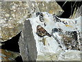
Early Medieval (Dark Age)Site Name: Farr Stone Alternative Name: Clach FarrCountry: Scotland County: Sutherland Type: Class II Pictish Symbol Stone
Nearest Town: Thurso Nearest Village: Bettyhill
Map Ref: NC7141662460
Latitude: 58.531197N Longitude: 4.210053W
Condition:
| 5 | Perfect |
| 4 | Almost Perfect |
| 3 | Reasonable but with some damage |
| 2 | Ruined but still recognisable as an ancient site |
| 1 | Pretty much destroyed, possibly visible as crop marks |
| 0 | No data. |
| -1 | Completely destroyed |
| 5 | Superb |
| 4 | Good |
| 3 | Ordinary |
| 2 | Not Good |
| 1 | Awful |
| 0 | No data. |
| 5 | Can be driven to, probably with disabled access |
| 4 | Short walk on a footpath |
| 3 | Requiring a bit more of a walk |
| 2 | A long walk |
| 1 | In the middle of nowhere, a nightmare to find |
| 0 | No data. |
| 5 | co-ordinates taken by GPS or official recorded co-ordinates |
| 4 | co-ordinates scaled from a detailed map |
| 3 | co-ordinates scaled from a bad map |
| 2 | co-ordinates of the nearest village |
| 1 | co-ordinates of the nearest town |
| 0 | no data |
Internal Links:
External Links:
I have visited· I would like to visit
jeffrep visited on 20th May 2013 - their rating: Cond: 4 Amb: 4 Access: 4
")
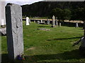
The basic design is a ringed cross, but this has been elaborated with decorated panels, blended with great skill to produce a harmonious whole. It probably dates from between 800 and 850 A.D.
Despite local tradition, there is no mystery about its origin. It marks the grave of an important local, religious, or political personage. The three small rough stones that stand nearby are certainly gravestones and may well be of the same age.
You may be viewing yesterday's version of this page. To see the most up to date information please register for a free account.
")
")
Do not use the above information on other web sites or publications without permission of the contributor.
golux has found this location on Google Street View:
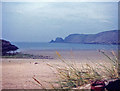
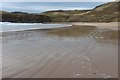
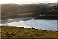
Nearby Images from Geograph Britain and Ireland:
©2012(licence)
©2005(licence)
©2019(licence)
©2009(licence)
©2009(licence)
The above images may not be of the site on this page, they are loaded from Geograph.
Please Submit an Image of this site or go out and take one for us!
Click here to see more info for this site
Nearby sites
Key: Red: member's photo, Blue: 3rd party photo, Yellow: other image, Green: no photo - please go there and take one, Grey: site destroyed
Download sites to:
KML (Google Earth)
GPX (GPS waypoints)
CSV (Garmin/Navman)
CSV (Excel)
To unlock full downloads you need to sign up as a Contributory Member. Otherwise downloads are limited to 50 sites.
Turn off the page maps and other distractions
Nearby sites listing. In the following links * = Image available
977m NNE 18° Clerkhill Broch or Nuraghe (NC71756338)
1.5km SSW 194° Cai Dun Broch or Nuraghe (NC7161)
1.5km ENE 75° Loch Swordily Broch or Nuraghe (NC729628)
1.7km E 82° Fiscary A (Farr)* Chambered Cairn (NC7310262629)
1.7km E 83° Fiscary B (Farr)* Chambered Cairn (NC7311262604)
1.8km E 87° Fiscary (Farr)* Cairn (NC7322062480)
2.0km SW 230° Baile Mhargaite Enclosure 1 Ancient Village or Settlement (NC6984361228)
2.0km SW 226° Baile Mhargaite Cist 1* Cist (NC6990861102)
2.2km SW 227° Baile Mhargaite* Broch or Nuraghe (NC6973560973)
2.6km ENE 76° Kirtomy Class I Pictish Symbol Stone (NC7463)
2.9km WSW 246° Dun Riaskidh* Chambered Cairn (NC68766140)
3.0km S 179° Achcoillenaborgie Broch or Nuraghe (NC71395942)
3.5km S 176° Coille na Borgie* Chambered Cairn (NC7154359000)
3.7km WSW 259° Torrisdail Broch or Nuraghe (NC67736185)
4.9km SW 228° Borgie Souterrain* Souterrain (Fogou, Earth House) (NC67625929)
5.0km SSE 166° Allt a' Chaisteil* Stone Circle (NC72515756)
5.0km SSE 167° Allt an Duin (Skelpick)* Broch or Nuraghe (NC72355752)
5.1km S 169° Skelpick Stone Rows Multiple Stone Rows / Avenue (NC722574)
5.4km SSE 148° Achamore Chambered Cairn (NC74175779)
5.8km S 170° Skelpick Chambered Cairn 1* Chambered Cairn (NC72255672)
6.1km S 171° Skelpick Chambered Cairn 2 Chambered Cairn (NC72175635)
6.4km SW 233° Borgie Stone Rows* Multiple Stone Rows / Avenue (NC66135874)
6.5km SSE 169° Skelpick Chambered Cairn 3 Chambered Cairn (NC72495605)
8.5km E 87° Broch near Armadale* Broch or Nuraghe (NC799626)
8.8km S 170° Loch Ma Naire* Holy Well or Sacred Spring (NC726537)
View more nearby sites and additional images


 We would like to know more about this location. Please feel free to add a brief description and any relevant information in your own language.
 Wir möchten mehr über diese Stätte erfahren. Bitte zögern Sie nicht, eine kurze Beschreibung und relevante Informationen in Deutsch hinzuzufügen.
 Nous aimerions en savoir encore un peu sur les lieux. S'il vous plaît n'hesitez pas à ajouter une courte description et tous les renseignements pertinents dans votre propre langue.
 Quisieramos informarnos un poco más de las lugares. No dude en añadir una breve descripción y otros datos relevantes en su propio idioma.