


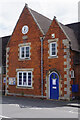
<< Our Photo Pages >> Bottesford Cross - Ancient Cross in England in Leicestershire and Rutland
Submitted by Anne T on Tuesday, 19 March 2019 Page Views: 1419
Early Medieval (Dark Age)Site Name: Bottesford Cross Alternative Name: Market Cross (Bottesford)Country: England County: Leicestershire and Rutland Type: Ancient Cross
Nearest Town: Melton Mowbray Nearest Village: Bottesford
Map Ref: SK8061638944
Latitude: 52.941843N Longitude: 0.801825W
Condition:
| 5 | Perfect |
| 4 | Almost Perfect |
| 3 | Reasonable but with some damage |
| 2 | Ruined but still recognisable as an ancient site |
| 1 | Pretty much destroyed, possibly visible as crop marks |
| 0 | No data. |
| -1 | Completely destroyed |
| 5 | Superb |
| 4 | Good |
| 3 | Ordinary |
| 2 | Not Good |
| 1 | Awful |
| 0 | No data. |
| 5 | Can be driven to, probably with disabled access |
| 4 | Short walk on a footpath |
| 3 | Requiring a bit more of a walk |
| 2 | A long walk |
| 1 | In the middle of nowhere, a nightmare to find |
| 0 | No data. |
| 5 | co-ordinates taken by GPS or official recorded co-ordinates |
| 4 | co-ordinates scaled from a detailed map |
| 3 | co-ordinates scaled from a bad map |
| 2 | co-ordinates of the nearest village |
| 1 | co-ordinates of the nearest town |
| 0 | no data |
Internal Links:
External Links:
I have visited· I would like to visit
Orcinus visited on 12th Jan 2022 - their rating: Cond: 2 Amb: 3 Access: 5
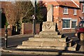
Anne T visited on 17th Mar 2019 - their rating: Cond: 3 Amb: 3 Access: 5 Market Cross, Bottesford: We saw this purely by chance as we turned down the road heading north towards the A1 and home, and stopped to take photographs. The village stocks and whipping post were right next to the cross, which was placed on top of five steps, the top two of which are modern repairs.
Average ratings for this site from all visit loggers: Condition: 2.5 Ambience: 3 Access: 5
")
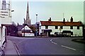
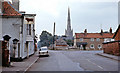
This market cross has two separate entries on Historic England: List ID 1075101 and List ID 1017494. Standing at the corner of Grantham Road and Market Street, this cross is thought to stand in or near its original position within the village, and thought to date from the 15th century.
Whilst the top two steps have been replaced, the rest of the steps are original, and are square in plan. Historic England adds: "On the uppermost step stands the socket stone, which is 0.74m square at its base and includes large stop-angles and shields on each of its four faces depicting the arms of the de Roos family. Set into the centre of the socket stone is the shaft, of square section at its base, rising through chamfered corners in tapering octagonal section to a maximum height of 0.97m. The full height of the cross is 2.47m".
Pastscape records this cross as Monument No 323732, where it is described as a "standing stone cross of medieval date".
Immediately next to the cross stands the village stocks and whipping post, which have their own Historic England entry (see List ID 1180323). Next to the cross is a large stone drinking trough, now reused as a planter.
You may be viewing yesterday's version of this page. To see the most up to date information please register for a free account.
")
")
")
Do not use the above information on other web sites or publications without permission of the contributor.
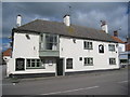
Nearby Images from Geograph Britain and Ireland:
©2021(licence)
©2010(licence)
©2012(licence)
©2007(licence)
©2022(licence)
The above images may not be of the site on this page, they are loaded from Geograph.
Please Submit an Image of this site or go out and take one for us!
Click here to see more info for this site
Nearby sites
Key: Red: member's photo, Blue: 3rd party photo, Yellow: other image, Green: no photo - please go there and take one, Grey: site destroyed
Download sites to:
KML (Google Earth)
GPX (GPS waypoints)
CSV (Garmin/Navman)
CSV (Excel)
To unlock full downloads you need to sign up as a Contributory Member. Otherwise downloads are limited to 50 sites.
Turn off the page maps and other distractions
Nearby sites listing. In the following links * = Image available
3.5km SSW 196° St Peter's Church (Redmile)* Early Christian Sculptured Stone (SK7971335528)
4.9km ENE 75° Salt Well* Holy Well or Sacred Spring (SK853403)
7.9km SSE 157° St Michael and All Angels (Harston)* Ancient Cross (SK8384031774)
9.5km NNW 332° Willow Rundle Spring* Holy Well or Sacred Spring (SK7602047230)
10.6km N 354° Hawton Cursus Cursus (SK79294949)
11.1km WNW 284° Old Wark Spring* Holy Well or Sacred Spring (SK698415)
11.3km WNW 285° Shelford and Newton Cursus Cursus (SK696417)
12.6km SSE 152° King Lud’s Intrenchments Misc. Earthwork (SK867279)
13.5km W 263° Stragglethorpe Bronze Age ring ditch* Round Barrow(s) (SK6720037057)
13.9km N 356° Farndon Fields* Natural Stone / Erratic / Other Natural Feature (SK794528)
14.4km SW 217° Long Clawson Stone* Standing Stone (Menhir) (SK722272)
14.9km SSE 161° St Bartholomew (Sproxton)* Ancient Cross (SK8566624904)
15.0km NNW 336° Rolleston Cross* Ancient Cross (SK7418052489)
15.0km NNW 336° Holy Trinity (Rolleston)* Ancient Cross (SK7418552503)
15.1km SW 231° St Luke (Hickling)* Early Christian Sculptured Stone (SK691292)
15.1km ENE 78° Honington Camp* Hillfort (SK954424)
15.3km SSW 206° Hazeltongue Lodge Henge (SK74092509)
15.9km SSE 147° Fish Well* Holy Well or Sacred Spring (SK89602578)
16.0km ESE 113° Burgh Banks Hillfort (SK955330)
16.3km SSW 214° Clawson Hose and Harby Cursus Cursus (SK718252)
16.7km SSW 209° Holwell Mouth* Holy Well or Sacred Spring (SK7269324230)
17.1km SW 224° Woundheal Spring* Holy Well or Sacred Spring (SK690264)
18.0km SSW 208° Ab Kettleby* Holy Well or Sacred Spring (SK724229)
18.1km WNW 289° Burton Lodge Fort Hillfort (SK63364461)
18.1km NW 326° Southwell Minster* Early Christian Sculptured Stone (SK70165378)
View more nearby sites and additional images


 We would like to know more about this location. Please feel free to add a brief description and any relevant information in your own language.
 Wir möchten mehr über diese Stätte erfahren. Bitte zögern Sie nicht, eine kurze Beschreibung und relevante Informationen in Deutsch hinzuzufügen.
 Nous aimerions en savoir encore un peu sur les lieux. S'il vous plaît n'hesitez pas à ajouter une courte description et tous les renseignements pertinents dans votre propre langue.
 Quisieramos informarnos un poco más de las lugares. No dude en añadir una breve descripción y otros datos relevantes en su propio idioma.