


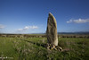
<< Our Photo Pages >> Sa Pedra 'e Taleri Menhir - Standing Stone (Menhir) in Italy in Sardinia (Sardegna)
Submitted by AlexHunger on Saturday, 25 March 2006 Page Views: 4157
Neolithic and Bronze AgeSite Name: Sa Pedra 'e Taleri MenhirCountry: Italy Region: Sardinia (Sardegna) Type: Standing Stone (Menhir)
Nearest Town: Nuoro Nearest Village: Noragugume
Latitude: 40.216070N Longitude: 8.946420E
Condition:
| 5 | Perfect |
| 4 | Almost Perfect |
| 3 | Reasonable but with some damage |
| 2 | Ruined but still recognisable as an ancient site |
| 1 | Pretty much destroyed, possibly visible as crop marks |
| 0 | No data. |
| -1 | Completely destroyed |
| 5 | Superb |
| 4 | Good |
| 3 | Ordinary |
| 2 | Not Good |
| 1 | Awful |
| 0 | No data. |
| 5 | Can be driven to, probably with disabled access |
| 4 | Short walk on a footpath |
| 3 | Requiring a bit more of a walk |
| 2 | A long walk |
| 1 | In the middle of nowhere, a nightmare to find |
| 0 | No data. |
| 5 | co-ordinates taken by GPS or official recorded co-ordinates |
| 4 | co-ordinates scaled from a detailed map |
| 3 | co-ordinates scaled from a bad map |
| 2 | co-ordinates of the nearest village |
| 1 | co-ordinates of the nearest town |
| 0 | no data |
Internal Links:
External Links:
I have visited· I would like to visit
SolarMegalith visited on 10th Sep 2009 - their rating: Cond: 5 Amb: 4 Access: 5
")
Positional co-ordinates scaled from a map source.
You may be viewing yesterday's version of this page. To see the most up to date information please register for a free account.
")
")
Do not use the above information on other web sites or publications without permission of the contributor.
Nearby Images from Flickr
The above images may not be of the site on this page, but were taken nearby. They are loaded from Flickr so please click on them for image credits.
Click here to see more info for this site
Nearby sites
Click here to view sites on an interactive map of the areaKey: Red: member's photo, Blue: 3rd party photo, Yellow: other image, Green: no photo - please go there and take one, Grey: site destroyed
Download sites to:
KML (Google Earth)
GPX (GPS waypoints)
CSV (Garmin/Navman)
CSV (Excel)
To unlock full downloads you need to sign up as a Contributory Member. Otherwise downloads are limited to 50 sites.
Turn off the page maps and other distractions
Nearby sites listing. In the following links * = Image available
229m WSW 250° Sa Pedra 'e Taleri Domus de Janas* Rock Cut Tomb
1.8km W 273° Tolinu Nuraghe* Broch or Nuraghe
2.6km WSW 243° Melas Tomba di Giganti* Chambered Tomb
2.7km WSW 239° Melas Protonuraghe* Broch or Nuraghe
2.7km WSW 252° Ladu Protonuraghe* Broch or Nuraghe
3.0km WSW 247° Serra Nuraghe (Sedilo)* Broch or Nuraghe
3.2km WSW 237° Columbos Nuraghe (Sedilo)* Broch or Nuraghe
4.0km NW 323° S'Ulivera Protonuraghe Broch or Nuraghe
4.3km N 1° Mura Ruja Tomba di Giganti Chambered Tomb
4.5km S 174° Orbezzari Nuraghe Broch or Nuraghe
4.5km N 357° Corbos Nuraghe* Broch or Nuraghe
4.7km N 1° S'Abbaia Tomba di Giganti* Chambered Tomb
5.0km SW 222° Lighei Tomba di Giganti* Chambered Tomb
5.1km SW 222° Lighei Nuraghe* Broch or Nuraghe
5.1km WNW 291° Sos Coloros Recinto Nuragico Ancient Village or Settlement
5.3km WNW 292° Lughe Dolmen Burial Chamber or Dolmen
5.6km N 352° Pedra Pinta Tomba di Giganti Chambered Tomb
6.1km S 176° Busurtei Nuraghe Broch or Nuraghe
6.2km SW 225° Puligone Nuraghe* Broch or Nuraghe
6.3km WNW 304° Cubas Protonuraghe Broch or Nuraghe
7.4km SSW 213° Iloi Villaggio Nuragico* Ancient Village or Settlement
7.4km SSW 212° Iloi Tomba di Giganti 1* Chambered Tomb
7.5km SSW 213° Iloi Nuraghe* Broch or Nuraghe
7.5km SSW 212° Iloi Tomba di Giganti 2* Chambered Tomb
7.5km SSW 211° Ispiluncas Domus de Janas* Rock Cut Tomb
View more nearby sites and additional images


 We would like to know more about this location. Please feel free to add a brief description and any relevant information in your own language.
 Wir möchten mehr über diese Stätte erfahren. Bitte zögern Sie nicht, eine kurze Beschreibung und relevante Informationen in Deutsch hinzuzufügen.
 Nous aimerions en savoir encore un peu sur les lieux. S'il vous plaît n'hesitez pas à ajouter une courte description et tous les renseignements pertinents dans votre propre langue.
 Quisieramos informarnos un poco más de las lugares. No dude en añadir una breve descripción y otros datos relevantes en su propio idioma.