

<< Our Photo Pages >> Leopards Open Sanctuary - Ancient Temple in Israel
Submitted by Motist on Thursday, 29 June 2006 Page Views: 7607
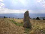
Neolithic and Bronze AgeSite Name: Leopards Open SanctuaryCountry: Israel Type: Ancient Temple
Nearest Town: Eilat Nearest Village: Neot Smadar
Latitude: 29.955772N Longitude: 34.969972E
Condition:
| 5 | Perfect |
| 4 | Almost Perfect |
| 3 | Reasonable but with some damage |
| 2 | Ruined but still recognisable as an ancient site |
| 1 | Pretty much destroyed, possibly visible as crop marks |
| 0 | No data. |
| -1 | Completely destroyed |
| 5 | Superb |
| 4 | Good |
| 3 | Ordinary |
| 2 | Not Good |
| 1 | Awful |
| 0 | No data. |
| 5 | Can be driven to, probably with disabled access |
| 4 | Short walk on a footpath |
| 3 | Requiring a bit more of a walk |
| 2 | A long walk |
| 1 | In the middle of nowhere, a nightmare to find |
| 0 | No data. |
| 5 | co-ordinates taken by GPS or official recorded co-ordinates |
| 4 | co-ordinates scaled from a detailed map |
| 3 | co-ordinates scaled from a bad map |
| 2 | co-ordinates of the nearest village |
| 1 | co-ordinates of the nearest town |
| 0 | no data |
Internal Links:
External Links:
")
The angles of the sanctuary point to the 4 cardinal points .
You may be viewing yesterday's version of this page. To see the most up to date information please register for a free account.
")
")
")
")
")
")
Do not use the above information on other web sites or publications without permission of the contributor.
Click here to see more info for this site
Nearby sites
Click here to view sites on an interactive map of the areaKey: Red: member's photo, Blue: 3rd party photo, Yellow: other image, Green: no photo - please go there and take one, Grey: site destroyed
Download sites to:
KML (Google Earth)
GPX (GPS waypoints)
CSV (Garmin/Navman)
CSV (Excel)
To unlock full downloads you need to sign up as a Contributory Member. Otherwise downloads are limited to 50 sites.
Turn off the page maps and other distractions
Nearby sites listing. In the following links * = Image available
278m SSW 195° East Uvda valley cult sites* Ancient Temple
1.4km SSW 204° Uvda Valley habitation site No 18* Ancient Village or Settlement
1.6km SSW 201° Uvda Valley habitation site No 9* Ancient Village or Settlement
4.7km SE 127° Mount Shacharut* Ancient Temple
5.4km ESE 111° Southern Itro pass * Stone Row / Alignment
5.6km E 85° Itro pass Roded Figurines* Ancient Temple
6.2km ENE 76° Top Itro pass 7 Matseboth* Standing Stone (Menhir)
6.5km SE 141° S' of Shacharut pass Open Air Sanctuaries* Ancient Temple
6.8km S 177° Wadi 'Isaron* Ancient Village or Settlement
7.4km S 174° North wadi Tse'ela open air sanctuary* Ancient Temple
7.4km N 4° Upper Wadi Hayun* Standing Stones
7.6km NNE 24° Mt. Na'atsuts cluster of megalithic Matseboth* Standing Stone (Menhir)
7.8km S 176° Wadi Tse'ela Habitation site* Ancient Village or Settlement
8.2km SE 140° Zugan Pass Cult Site* Ancient Temple
9.0km SW 214° Wadi Hagdera-'Uvda camp & cult site* Ancient Village or Settlement
9.0km NE 54° Mount Ayah* Ancient Temple
9.1km ENE 67° Grofit hights* Ancient Temple
10.1km WSW 239° South 'Uvda Valley Matseboth* Standing Stones
11.0km NE 53° Mt. 'Ai'it sites* Ancient Temple
12.1km NE 44° Upper Wadi Qtura Flint Workshop* Ancient Mine, Quarry or other Industry
12.1km NE 44° Upper Wadi Qtura Massebah* Standing Stone (Menhir)
12.2km NE 49° Upper Qtura Pass Masseboth* Standing Stones
12.6km NE 56° lower wadi Qtura* Ancient Village or Settlement
13.0km NNE 31° Mt. Shizzafon camp site* Ancient Village or Settlement
13.3km NE 48° Mt. Qtura Roded type open air sanctuary* Ancient Temple
View more nearby sites and additional images


 We would like to know more about this location. Please feel free to add a brief description and any relevant information in your own language.
 Wir möchten mehr über diese Stätte erfahren. Bitte zögern Sie nicht, eine kurze Beschreibung und relevante Informationen in Deutsch hinzuzufügen.
 Nous aimerions en savoir encore un peu sur les lieux. S'il vous plaît n'hesitez pas à ajouter une courte description et tous les renseignements pertinents dans votre propre langue.
 Quisieramos informarnos un poco más de las lugares. No dude en añadir una breve descripción y otros datos relevantes en su propio idioma.