 with our Megalithic Portal iPhone app")


<< Our Photo Pages >> Holm of Rendall - Cairn in Scotland in Orkney
Submitted by howar on Saturday, 18 April 2015 Page Views: 2038
Neolithic and Bronze AgeSite Name: Holm of RendallCountry: Scotland County: Orkney Type: Cairn
Nearest Town: Finstown Nearest Village: Norseman
Map Ref: HY4283220735
Latitude: 59.069716N Longitude: 2.998802W
Condition:
| 5 | Perfect |
| 4 | Almost Perfect |
| 3 | Reasonable but with some damage |
| 2 | Ruined but still recognisable as an ancient site |
| 1 | Pretty much destroyed, possibly visible as crop marks |
| 0 | No data. |
| -1 | Completely destroyed |
| 5 | Superb |
| 4 | Good |
| 3 | Ordinary |
| 2 | Not Good |
| 1 | Awful |
| 0 | No data. |
| 5 | Can be driven to, probably with disabled access |
| 4 | Short walk on a footpath |
| 3 | Requiring a bit more of a walk |
| 2 | A long walk |
| 1 | In the middle of nowhere, a nightmare to find |
| 0 | No data. |
| 5 | co-ordinates taken by GPS or official recorded co-ordinates |
| 4 | co-ordinates scaled from a detailed map |
| 3 | co-ordinates scaled from a bad map |
| 2 | co-ordinates of the nearest village |
| 1 | co-ordinates of the nearest town |
| 0 | no data |
Internal Links:
External Links:
I have visited· I would like to visit
whese001 would like to visit
")
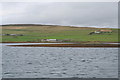
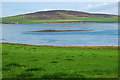
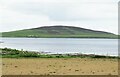
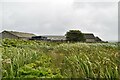
On an islet. The cairn on the Holm of Rendall has no report I can find, official or unofficial, and you can't walk to it. But recently I was able to observe it from the road above at low tide around the time of the eclipse and it is obvious that it used to be connected to the mainland as I saw only a small water channel between the two rocky shorelines, wouldn't be surprised if you could wade to it like the bloke did to Damsay. And there appears to be a causeway curving around from the cairn to follow the disappeared 'land-bridge' to land close to the Iron Age site of Tammaskirk. But another view could show this as part of a strange quartering of the islet. Even a low tide from the sea's edge below the Ha' of Rendall couldn't get me close enough for a detailed image of the cairn. However the stones below the turf too darn regular to be natural, there's just something about the way they look (though I'm sure I'm only imaging a herringbone effect).
You may be viewing yesterday's version of this page. To see the most up to date information please register for a free account.
")
")
")
Do not use the above information on other web sites or publications without permission of the contributor.
Nearby Images from Geograph Britain and Ireland:
©2008(licence)
©2006(licence)
©2012(licence)
©2021(licence)
©2024(licence)
The above images may not be of the site on this page, they are loaded from Geograph.
Please Submit an Image of this site or go out and take one for us!
Click here to see more info for this site
Nearby sites
Key: Red: member's photo, Blue: 3rd party photo, Yellow: other image, Green: no photo - please go there and take one, Grey: site destroyed
Download sites to:
KML (Google Earth)
GPX (GPS waypoints)
CSV (Garmin/Navman)
CSV (Excel)
To unlock full downloads you need to sign up as a Contributory Member. Otherwise downloads are limited to 50 sites.
Turn off the page maps and other distractions
Nearby sites listing. In the following links * = Image available
801m SSW 199° Knowe of Dishero* Broch or Nuraghe (HY42561998)
2.7km NE 51° Gairsay Cairn (HY44942237)
3.2km WSW 245° Sandyhall* Barrow Cemetery (HY399194)
3.4km NW 306° Tingwall Broch* Broch or Nuraghe (HY401228)
3.5km SW 234° St Mary's Kirk, Isbister* Broch or Nuraghe (HY39971872)
3.5km W 269° Seven Knowes* Barrow Cemetery (HY39282072)
4.2km NW 313° Knowe of Midgarth* Ancient Village or Settlement (HY39812361)
4.7km SW 234° Oyce of Isbister* Round Barrow(s) (HY39021802)
5.0km NW 325° Ness of Woodwick* Broch or Nuraghe (HY40072487)
5.7km NNE 16° Braes of Ha’Breck, Wyre. Ancient Village or Settlement (HY445262)
5.9km W 261° Black Knowe of Blubbersdale* Round Barrow(s) (HY36951988)
5.9km SE 138° Twi Ness* Cairn (HY46761625)
6.2km SW 234° Broch of Redland* Broch or Nuraghe (HY37801715)
6.3km NW 310° Redland South* Chambered Cairn (HY38002484)
6.3km SE 135° Setter Noost* Ancient Village or Settlement (HY47301621)
6.5km SW 217° Burness* Broch or Nuraghe (HY38821557)
6.6km NW 310° Quoys Chambered Cairn Chambered Cairn (HY37822507)
6.6km NNW 347° Knowe of Hunclett* Broch or Nuraghe (HY41442722)
6.9km N 357° Taversoe Tuick* Chambered Cairn (HY42572761)
6.9km S 183° Ramberry Cairn Chambered Cairn (HY42401383)
7.0km NNW 348° Blackhammer* Chambered Tomb (HY41422761)
7.1km WSW 238° Redland settlement Ancient Village or Settlement (HY367171)
7.2km WSW 252° The Lyde Stones* Standing Stone (Menhir) (HY3596718643)
7.2km NNW 339° Langstane (Orkney)* Standing Stone (Menhir) (HY404275)
7.3km NNW 337° Knowe of Burrian (Frotoft)* Broch or Nuraghe (HY40062745)
View more nearby sites and additional images


 We would like to know more about this location. Please feel free to add a brief description and any relevant information in your own language.
 Wir möchten mehr über diese Stätte erfahren. Bitte zögern Sie nicht, eine kurze Beschreibung und relevante Informationen in Deutsch hinzuzufügen.
 Nous aimerions en savoir encore un peu sur les lieux. S'il vous plaît n'hesitez pas à ajouter une courte description et tous les renseignements pertinents dans votre propre langue.
 Quisieramos informarnos un poco más de las lugares. No dude en añadir una breve descripción y otros datos relevantes en su propio idioma.