

<< Our Photo Pages >> Cerne Abbas Giant - Hill Figure or Geoglyph in England in Dorset
Submitted by JimChampion on Saturday, 02 November 2013 Page Views: 40081
Multi-periodSite Name: Cerne Abbas GiantCountry: England County: Dorset Type: Hill Figure or Geoglyph
Nearest Town: Dorchester Nearest Village: Cerne Abbas
Map Ref: ST66660168 Landranger Map Number: 194
Latitude: 50.813702N Longitude: 2.474597W
Condition:
| 5 | Perfect |
| 4 | Almost Perfect |
| 3 | Reasonable but with some damage |
| 2 | Ruined but still recognisable as an ancient site |
| 1 | Pretty much destroyed, possibly visible as crop marks |
| 0 | No data. |
| -1 | Completely destroyed |
| 5 | Superb |
| 4 | Good |
| 3 | Ordinary |
| 2 | Not Good |
| 1 | Awful |
| 0 | No data. |
| 5 | Can be driven to, probably with disabled access |
| 4 | Short walk on a footpath |
| 3 | Requiring a bit more of a walk |
| 2 | A long walk |
| 1 | In the middle of nowhere, a nightmare to find |
| 0 | No data. |
| 5 | co-ordinates taken by GPS or official recorded co-ordinates |
| 4 | co-ordinates scaled from a detailed map |
| 3 | co-ordinates scaled from a bad map |
| 2 | co-ordinates of the nearest village |
| 1 | co-ordinates of the nearest town |
| 0 | no data |
Internal Links:
External Links:
I have visited· I would like to visit
shawid would like to visit
wildtalents visited on 27th Jun 2023 - their rating: Cond: 4 Amb: 2 Access: 5 Viewed from the tourist car park it is a bit disappointing: you can't necessarily make out the whole outline of this chalk giant. When I get my helicopter license I'll have a better look. But if you're nearby it's worth a quick look-see.
hevveh saw from a distance on 24th Sep 2022
custer visited on 6th Apr 2012 - their rating: Cond: 4 Amb: 4 Access: 4 Good walk from car park at main road, earthworks on top of hill, nice place, some good stories like the references to Oliver Cromwell.
trystan_hughes visited on 1st May 2009 - their rating: Cond: 4 Amb: 5 Access: 4
woodini254 visited on 10th Oct 1994 - their rating: Cond: 5 Amb: 4 Access: 3
TheCaptain maddy myf JimChampion X-Ice Wazza12 have visited here
Average ratings for this site from all visit loggers: Condition: 4.25 Ambience: 3.75 Access: 4
")
The antiquity of the Giant is still a topic of debate. The various interpretations suggest that he might be a prehistoric fertility symbol (not surprising considering his disproportionately large phallus), a Romano-British depiction of Hercules or some other god of war, or even a huge 'cartoon' from the seventeenth century lampooning Oliver Cromwell.
Access Assuming that you don't have the power of flight, the Giant is best viewed from the far side of the Cerne valley. He is clearly visible from the A352 road and there is a 'viewing area' with car parking spaces, picnic benches and interpretation board next to the turning to Cerne Abbas village. A waymarked "Giant Walk" takes the pedestrian visitor past his feet, but due to severe erosion of the turf the public is requested to remain outside the barbed-wire fence.
Note: The Cerne Abbas Giant has grown his own Movember facial hair in support of Movember, which raises awareness of prostate and testicular cancer.
You may be viewing yesterday's version of this page. To see the most up to date information please register for a free account.
")
")
")
")
")
")
")
")
")
")
")
")
")
")
")
")
")
")
")
")
")
")
")
")
These are just the first 25 photos of Cerne Abbas Giant. If you log in with a free user account you will be able to see our entire collection.
Do not use the above information on other web sites or publications without permission of the contributor.
Click here to see more info for this site
Nearby sites
Key: Red: member's photo, Blue: 3rd party photo, Yellow: other image, Green: no photo - please go there and take one, Grey: site destroyed
Download sites to:
KML (Google Earth)
GPX (GPS waypoints)
CSV (Garmin/Navman)
CSV (Excel)
To unlock full downloads you need to sign up as a Contributory Member. Otherwise downloads are limited to 50 sites.
![]()
![]()
![]()
Turn off the page maps and other distractions
Nearby sites listing. In the following links * = Image available
71m E 98° The Trendle* Misc. Earthwork (ST66730167)
126m NNE 18° Giant Hill Cross Ridge Dyke Misc. Earthwork (ST667018)
215m NNE 27° Giant Hill Bowl Barrow Round Barrow(s) (ST66760187)
312m S 183° St Augustine's Well (Cerne Abbas)* Holy Well or Sacred Spring (ST6664001369)
639m NNE 27° Giant Hill Settlement Ancient Village or Settlement (ST66950225)
713m NNE 31° Bowl Barrow (Dorset) Round Barrow(s) (ST67030229)
1.1km ESE 105° Alton Lane Field System Misc. Earthwork (ST677014)
1.3km W 266° Weam Commen Hill Field System Misc. Earthwork (ST654016)
1.3km SSE 155° Black Hill Farm Enclosure Ancient Village or Settlement (ST672005)
1.7km SSE 154° Oxencombe Bottom Bowl Barrow Round Barrow(s) (ST67380018)
1.7km WNW 293° Seldon Hill Settlement Ancient Village or Settlement (ST65100235)
1.7km SW 215° Dickley Hill Settlement Ancient Village or Settlement (ST65650027)
1.8km SW 216° Dickley Hill Bowl Barrows Round Barrow(s) (ST65600026)
1.8km NNW 328° High Cank Henge Henge (ST65720319)
1.8km NNW 335° Farm Hill Bowl Barrow Round Barrow(s) (ST65880334)
1.9km W 279° Wancombe Hill Field System Misc. Earthwork (ST64790200)
2.2km WSW 246° Up Cerne/Sydling St Nicholas Boundary Stone Marker Stone (ST64610078)
2.3km S 170° Green Hill Barrows Barrow Cemetery (SY67069943)
2.4km SSW 200° Smacam Down Bowl Barrow Round Barrow(s) (SY65859946)
2.4km SSE 167° Green Hill Field System Misc. Earthwork (SY672993)
2.5km SSW 202° Smacam Down Settlement Ancient Village or Settlement (SY657994)
2.5km SSW 202° Smacam Down Long Barrow Long Barrow (SY6572599389)
2.8km NNW 329° East Hill field System* Misc. Earthwork (ST65250405)
3.4km NNW 332° St Mary's Well (Hermitage)* Holy Well or Sacred Spring (ST651047)
3.8km SSW 193° Nether Cerne Field System Misc. Earthwork (SY658980)
View more nearby sites and additional images


 We would like to know more about this location. Please feel free to add a brief description and any relevant information in your own language.
 Wir möchten mehr über diese Stätte erfahren. Bitte zögern Sie nicht, eine kurze Beschreibung und relevante Informationen in Deutsch hinzuzufügen.
 Nous aimerions en savoir encore un peu sur les lieux. S'il vous plaît n'hesitez pas à ajouter une courte description et tous les renseignements pertinents dans votre propre langue.
 Quisieramos informarnos un poco más de las lugares. No dude en añadir una breve descripción y otros datos relevantes en su propio idioma.
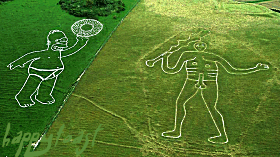