

<< Our Photo Pages >> Edenhall Cross (Langwathby) - Ancient Cross in England in Cumbria
Submitted by Anne T on Friday, 06 April 2018 Page Views: 2758
Early Medieval (Dark Age)Site Name: Edenhall Cross (Langwathby)Country: England County: Cumbria Type: Ancient Cross
Nearest Town: Penrith Nearest Village: Edenhall / Langwathby
Map Ref: NY5676732230
Latitude: 54.683256N Longitude: 2.67208W
Condition:
| 5 | Perfect |
| 4 | Almost Perfect |
| 3 | Reasonable but with some damage |
| 2 | Ruined but still recognisable as an ancient site |
| 1 | Pretty much destroyed, possibly visible as crop marks |
| 0 | No data. |
| -1 | Completely destroyed |
| 5 | Superb |
| 4 | Good |
| 3 | Ordinary |
| 2 | Not Good |
| 1 | Awful |
| 0 | No data. |
| 5 | Can be driven to, probably with disabled access |
| 4 | Short walk on a footpath |
| 3 | Requiring a bit more of a walk |
| 2 | A long walk |
| 1 | In the middle of nowhere, a nightmare to find |
| 0 | No data. |
| 5 | co-ordinates taken by GPS or official recorded co-ordinates |
| 4 | co-ordinates scaled from a detailed map |
| 3 | co-ordinates scaled from a bad map |
| 2 | co-ordinates of the nearest village |
| 1 | co-ordinates of the nearest town |
| 0 | no data |
Internal Links:
External Links:
I have visited· I would like to visit
KieKa would like to visit
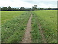
Anne T visited on 5th Apr 2018 - their rating: Cond: 3 Amb: 4 Access: 5 Edenhall Cross, near Langwathby, Cumbria: This is one of the crosses we didn't have time to visit on our last trip to Cumbria, and we picked a beautiful, if somewhat chilly day, to arrive.
No sooner had we pulled the car up by the cross to take some photographs, and I was wrestling with the lens of my camera, which had jammed, when a dog walker sidled up and asked us if we were planning on parking there. I said I was just going to take some photos, then we were heading down to the church; we wouldn't dream of blocking the gate into the field. The man looked mollified and moved on, only to be followed by a steady stream of dog walkers with large dogs.
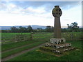
The view across to the Pennines with their snow caps was lovely. The photographs didn't really do the scenery justice. A lovely spot.
 (PID:179870)")
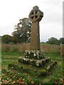
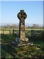
This grade II listed cross is made up of a 19th century cross shaft and head on a medieval plinth. The plinth measures 2m square. Sitting at the side of the lane leading from Edenhall village to St. Cuthbert's Church, a footpath leads south east across the fields from the cross to the River Eden.
Recorded as Historic England List ID 1019726 and Pastscape Monument No. 12259, all the components are made of red sandstone.
With views east across the river to the Pennine ridge beyond, it is in a very pleasant location. The St. Cuthbert Church guide says that a nearby wall was taken down in the early 1870s. "The stones were carried away to be used in building a retaining wall along the west side of the Ladies' Walk. Built into the wall was found a small water trough believed to have been used as a plague stone. The trough was taken away and the cross was erected to mark the place. What became of the trough is not known."
You may be viewing yesterday's version of this page. To see the most up to date information please register for a free account.
 (PID:179871)")
 (PID:179872)")
Do not use the above information on other web sites or publications without permission of the contributor.
Nearby Images from Geograph Britain and Ireland:
©2021(licence)
©2018(licence)
©2010(licence)
©2023(licence)
©2010(licence)
The above images may not be of the site on this page, they are loaded from Geograph.
Please Submit an Image of this site or go out and take one for us!
Click here to see more info for this site
Nearby sites
Key: Red: member's photo, Blue: 3rd party photo, Yellow: other image, Green: no photo - please go there and take one, Grey: site destroyed
Download sites to:
KML (Google Earth)
GPX (GPS waypoints)
CSV (Garmin/Navman)
CSV (Excel)
To unlock full downloads you need to sign up as a Contributory Member. Otherwise downloads are limited to 50 sites.
Turn off the page maps and other distractions
Nearby sites listing. In the following links * = Image available
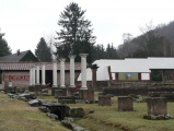
226m SE 144° St. Cuthbert's Church (Edenhall)* Ancient Cross (NY5689832046)
388m WSW 250° St Cuthbert's Well (Edenhall Park)* Holy Well or Sacred Spring (NY564321)
2.1km SSW 198° Giant's Cave (Cumbria)* Cave or Rock Shelter (NY56093027)
2.1km SSW 198° Giants Cave Holy Well (Edenhall)* Holy Well or Sacred Spring (NY5610030200)
2.4km SSW 197° St Ninian's Preconquest Monastery (Ninekirks)* Ancient Village or Settlement (NY5607129981)
2.4km SSW 200° St Ninian's Church (Ninekirks)* Ancient Cross (NY5593629962)
4.0km WSW 246° Dickey Bank Holy Well (Carleton Hill) Holy Well or Sacred Spring (NY5309030660)
4.2km SE 137° Winderwath Stone Circle* Stone Circle (NY5960729085)
4.9km N 3° Long Meg* Standing Stone (Menhir) (NY57063716)
5.0km N 357° Hunsonby Cursus Cursus (NY56543719)
5.0km N 3° Long Meg And Her Daughters* Stone Circle (NY57113721)
5.3km N 9° Little Meg* Stone Circle (NY5769037479)
5.5km WSW 240° Plague Stone (Penrith)* Ancient Cross (NY5196329563)
5.5km WSW 247° Giants Grave, Penrith* Ancient Cross (NY51653017)
5.6km WSW 250° Penrith Museum* Museum (NY5144830339)
5.9km SW 228° King Arthur's Round Table* Henge (NY5232528374)
5.9km S 184° Leacet Hill* Cairn (NY563263)
6.0km SW 227° Little Round Table* Henge (NY52382817)
6.1km N 6° Addingham Cross* Ancient Cross (NY57443829)
6.1km SW 231° Mayburgh* Henge (NY5191728428)
6.4km SW 228° Brougham Hall Stone Circle (NY520280)
6.7km SSW 208° St Cuthbert's Well (Clifton)* Holy Well or Sacred Spring (NY5359326336)
6.7km ENE 71° St Luke's Church (Townhead)* Ancient Cross (NY6317734328)
6.7km WSW 238° Skirsgill Standing Stone* Standing Stone (Menhir) (NY50972875)
6.9km WSW 237° Skirsgill Holy Well (Skirsgill) Holy Well or Sacred Spring (NY5095028560)
View more nearby sites and additional images


 We would like to know more about this location. Please feel free to add a brief description and any relevant information in your own language.
 Wir möchten mehr über diese Stätte erfahren. Bitte zögern Sie nicht, eine kurze Beschreibung und relevante Informationen in Deutsch hinzuzufügen.
 Nous aimerions en savoir encore un peu sur les lieux. S'il vous plaît n'hesitez pas à ajouter une courte description et tous les renseignements pertinents dans votre propre langue.
 Quisieramos informarnos un poco más de las lugares. No dude en añadir una breve descripción y otros datos relevantes en su propio idioma.