


<< Our Photo Pages >> Bowl and Bell Barrow - Barrow Cemetery in England in Wiltshire
Submitted by Horatio on Thursday, 25 April 2024 Page Views: 22
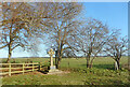
Neolithic and Bronze AgeSite Name: Bowl and Bell Barrow Alternative Name: Bowl and Bell barrows Fargo PlantationCountry: England County: Wiltshire Type: Barrow Cemetery
Nearest Town: Amesbury Nearest Village: Larkhill
Map Ref: SU11454270
Latitude: 51.183417N Longitude: 1.837563W
Condition:
| 5 | Perfect |
| 4 | Almost Perfect |
| 3 | Reasonable but with some damage |
| 2 | Ruined but still recognisable as an ancient site |
| 1 | Pretty much destroyed, possibly visible as crop marks |
| 0 | No data. |
| -1 | Completely destroyed |
| 5 | Superb |
| 4 | Good |
| 3 | Ordinary |
| 2 | Not Good |
| 1 | Awful |
| 0 | No data. |
| 5 | Can be driven to, probably with disabled access |
| 4 | Short walk on a footpath |
| 3 | Requiring a bit more of a walk |
| 2 | A long walk |
| 1 | In the middle of nowhere, a nightmare to find |
| 0 | No data. |
| 5 | co-ordinates taken by GPS or official recorded co-ordinates |
| 4 | co-ordinates scaled from a detailed map |
| 3 | co-ordinates scaled from a bad map |
| 2 | co-ordinates of the nearest village |
| 1 | co-ordinates of the nearest town |
| 0 | no data |
Internal Links:
External Links:
")
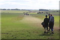
Two Barrows in close proximity to each other, just south of the Stonehenge Cursus and both monuments form part of the Cursus round barrow cemetery. which contains 16 round barrows in all, including seven bowl barrows, six bell barrows, a twin bell barrow and a disc barrow.
The closest to Fargo plantation being a Bell barrow and the other the more common Bowl Barrow type.
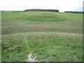
The Bell barrow has a mound 35m in diameter and 1.5m high, surrounded by a berm which is no longer visible, and a ditch 4m wide and 0.2m deep, giving an overall diameter of 43m. The ditch, from which material was quarried during the construction of the monument, is most obvious on the west of the mound but difficult to distinguish elsewhere. It does, however, survive as a buried feature. Partial excavation in the 19th century revealed a primary inhumation with a beaker and two secondary inhumations. Further partial excavation in 1960 revealed evidence of a berm surrounding the central mound and finds which included decayed leather, and a contracted inhumation burial lying beneath a tapered board and accompanied by a long-necked beaker and various implements. The ditch silt contained a bell beaker and another contracted inhumation. Fragments of blue-stone were also found.
The Bowl Barrow has a mound is 25m in diameter and 1.75m high, surrounded by a ditch from which material was quarried during its construction. This is now difficult to identify on the ground but is represented on the OS 1:2500 scale map of 1972 from which it is calculated to be 2.5m wide, giving an overall diameter of 30m.
You may be viewing yesterday's version of this page. To see the most up to date information please register for a free account.
Do not use the above information on other web sites or publications without permission of the contributor.
Nearby Images from Geograph Britain and Ireland:
©2020(licence)
©2011(licence)
©2008(licence)
©2014(licence)
©2022(licence)
The above images may not be of the site on this page, they are loaded from Geograph.
Please Submit an Image of this site or go out and take one for us!
Click here to see more info for this site
Nearby sites
Key: Red: member's photo, Blue: 3rd party photo, Yellow: other image, Green: no photo - please go there and take one, Grey: site destroyed
Download sites to:
KML (Google Earth)
GPX (GPS waypoints)
CSV (Garmin/Navman)
CSV (Excel)
To unlock full downloads you need to sign up as a Contributory Member. Otherwise downloads are limited to 50 sites.
Turn off the page maps and other distractions
Nearby sites listing. In the following links * = Image available
303m W 280° Fargo Disk Barrow* Round Barrow(s) (SU11154275)
446m E 80° Great Cursus Barrows, Stonehenge* Round Barrow(s) (SU11894278)
584m WNW 290° Amesbury Cursus (W)* Cursus (SU109429)
625m ESE 119° Stonehenge Car Park Postholes* Timber Circle (SU120424)
662m ENE 67° Great Cursus, Stonehenge* Cursus (SU12064296)
942m ESE 123° Stonehenge.* Stone Circle (SU1224742194)
951m S 174° North of Normanton Gorse Barrows* Barrow Cemetery (SU1154441754)
955m ESE 119° Heel Stone* Standing Stone (Menhir) (SU1229142244)
962m ENE 69° Great Cursus W Barrow* Round Barrow(s) (SU1235143043)
1.1km ESE 119° Stonehenge Bowl Barrow* Round Barrow(s) (SU12424217)
1.2km NW 320° Winterbourne Stoke Cursus (E) Cursus (SU107436)
1.2km E 94° The Avenue* Ancient Trackway (SU12694262)
1.3km NW 304° The Lesser Cursus* Cursus (SU10354343)
1.3km WNW 302° Winterbourne Stoke Cursus (W) Cursus (SU103434)
1.3km W 274° Stonehenge Visitor Centre* Museum (SU101428)
1.4km SSW 206° Pond Barrow and Wilsford Shaft Round Barrow(s) (SU1086441475)
1.4km WSW 257° North of Winterbourne Stoke Crossroads* Barrow Cemetery (SU1004742378)
1.5km S 173° Bush Barrow* Round Barrow(s) (SU11644126)
1.5km SSE 167° Normanton Down* Barrow Cemetery (SU118412)
1.6km SW 232° Winterbourne Stoke* Barrow Cemetery (SU10174171)
1.6km S 181° Normanton Down Long Barrow* Long Barrow (SU1141341071)
1.8km ESE 111° Amesbury 39 Bowl Barrow* Round Barrow(s) (SU13154204)
1.8km SW 229° Long Barrow Cross* Ancient Cross (SU1005441499)
2.0km NNE 31° Long Barrow alongside The Packway, Larkhill* Long Barrow (SU12474438)
2.1km ESE 104° New King Barrows* Barrow Cemetery (SU13454222)
View more nearby sites and additional images


 We would like to know more about this location. Please feel free to add a brief description and any relevant information in your own language.
 Wir möchten mehr über diese Stätte erfahren. Bitte zögern Sie nicht, eine kurze Beschreibung und relevante Informationen in Deutsch hinzuzufügen.
 Nous aimerions en savoir encore un peu sur les lieux. S'il vous plaît n'hesitez pas à ajouter une courte description et tous les renseignements pertinents dans votre propre langue.
 Quisieramos informarnos un poco más de las lugares. No dude en añadir una breve descripción y otros datos relevantes en su propio idioma.