 with our Megalithic Portal iPhone app")


<< Our Photo Pages >> Carn Brea Well - Holy Well or Sacred Spring in England in Cornwall
Submitted by Thorgrim on Monday, 29 March 2004 Page Views: 10945
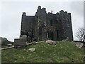
Springs and Holy WellsSite Name: Carn Brea WellCountry: England County: Cornwall Type: Holy Well or Sacred Spring
Nearest Town: Camborne Nearest Village: Carn Brea
Map Ref: SW68584085 Landranger Map Number: 203
Latitude: 50.222275N Longitude: 5.245646W
Condition:
| 5 | Perfect |
| 4 | Almost Perfect |
| 3 | Reasonable but with some damage |
| 2 | Ruined but still recognisable as an ancient site |
| 1 | Pretty much destroyed, possibly visible as crop marks |
| 0 | No data. |
| -1 | Completely destroyed |
| 5 | Superb |
| 4 | Good |
| 3 | Ordinary |
| 2 | Not Good |
| 1 | Awful |
| 0 | No data. |
| 5 | Can be driven to, probably with disabled access |
| 4 | Short walk on a footpath |
| 3 | Requiring a bit more of a walk |
| 2 | A long walk |
| 1 | In the middle of nowhere, a nightmare to find |
| 0 | No data. |
| 5 | co-ordinates taken by GPS or official recorded co-ordinates |
| 4 | co-ordinates scaled from a detailed map |
| 3 | co-ordinates scaled from a bad map |
| 2 | co-ordinates of the nearest village |
| 1 | co-ordinates of the nearest town |
| 0 | no data |
Internal Links:
External Links:
I have visited· I would like to visit
micske would like to visit
LiveAndrew visited on 25th Mar 2021 - their rating: Cond: 3 Amb: 4 Access: 3 Made the mistake of trying to find the well from the bottom of the North slope using an OS map. It would have been much easier from the top!
FrothNinja couldn't find on 6th Aug 2016 - their rating: Access: 1
lucasn visited - their rating: Cond: 3 Amb: 3 Access: 5
Average ratings for this site from all visit loggers: Condition: 3 Ambience: 3.5 Access: 3
")
Have you visited this site? Please add a comment below.
You may be viewing yesterday's version of this page. To see the most up to date information please register for a free account.
")
")
")
")
Do not use the above information on other web sites or publications without permission of the contributor.
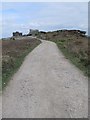
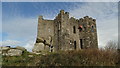
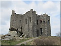
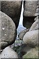
Nearby Images from Geograph Britain and Ireland:
©2013(licence)
©2017(licence)
©2013(licence)
©2014(licence)
©2023(licence)
The above images may not be of the site on this page, they are loaded from Geograph.
Please Submit an Image of this site or go out and take one for us!
Click here to see more info for this site
Nearby sites
Key: Red: member's photo, Blue: 3rd party photo, Yellow: other image, Green: no photo - please go there and take one, Grey: site destroyed
Download sites to:
KML (Google Earth)
GPX (GPS waypoints)
CSV (Garmin/Navman)
CSV (Excel)
To unlock full downloads you need to sign up as a Contributory Member. Otherwise downloads are limited to 50 sites.
Turn off the page maps and other distractions
Nearby sites listing. In the following links * = Image available
170m SSW 206° Carn Brea Enclosure* Ancient Village or Settlement (SW685407)
192m SE 139° Menhir Carn Brea (Redruth)* Standing Stone (Menhir) (SW687407)
686m NE 47° St Euny's Well (Carn Brea)* Holy Well or Sacred Spring (SW691413)
1.1km SW 231° Bosleake Stones* Modern Stone Circle etc (SW67674018)
1.5km SSE 153° Carnkie tumuli* Barrow Cemetery (SW692395)
1.6km SW 223° Canarthen Cross* Ancient Cross (SW67453973)
1.6km NE 45° St Rumon's Cross* Ancient Cross (SW69804195)
2.1km WNW 288° Camborne School of Mines Geological Museum Museum (SW666416)
2.5km SSE 161° Gregwartha Tumuli* Barrow Cemetery (SW693385)
2.9km E 92° Figgy Dowdy's Well* Holy Well or Sacred Spring (SW7146740637)
3.2km SSW 194° Vincent's Well Holy Well or Sacred Spring (SW677378)
3.5km NW 321° Mary's Well (Illogan)* Holy Well or Sacred Spring (SW66484369)
3.7km SE 137° Penhalvean Cross* Ancient Cross (SW71003799)
3.8km SW 225° St Ia's Well (Troon)* Holy Well or Sacred Spring (SW658383)
3.9km W 262° St Meriasek's Well* Holy Well or Sacred Spring (SW6464640480)
3.9km WSW 256° Camborne Cross* Ancient Cross (SW64704005)
4.0km WSW 254° Killivose Cross* Ancient Cross (SW64683995)
4.1km WSW 256° St Martin and St Meriadoc Cross Ancient Cross (SW64524003)
4.1km WSW 257° Maen Cadoar* Standing Stone (Menhir) (SW645401)
4.2km WSW 256° St Ia's Cross* Ancient Cross (SW64504002)
4.3km SSE 165° Carnmenellis Outcrop* Rock Outcrop (SW69533669)
4.3km S 181° Wendron North* Stone Circle (SW68293656)
4.3km S 181° Wendron South* Stone Circle (SW68313654)
4.3km SW 233° The Rocks* Rock Outcrop (SW650384)
4.4km SSW 194° Hangman's Barrow* Cairn (SW67333665)
View more nearby sites and additional images


 We would like to know more about this location. Please feel free to add a brief description and any relevant information in your own language.
 Wir möchten mehr über diese Stätte erfahren. Bitte zögern Sie nicht, eine kurze Beschreibung und relevante Informationen in Deutsch hinzuzufügen.
 Nous aimerions en savoir encore un peu sur les lieux. S'il vous plaît n'hesitez pas à ajouter une courte description et tous les renseignements pertinents dans votre propre langue.
 Quisieramos informarnos un poco más de las lugares. No dude en añadir una breve descripción y otros datos relevantes en su propio idioma.