


<< Text Pages >> Danebury West - Long Barrow in England in Hampshire
Submitted by JimChampion on Thursday, 02 June 2005 Page Views: 4193
Neolithic and Bronze AgeSite Name: Danebury WestCountry: England County: Hampshire Type: Long Barrow
Nearest Village: Nether Wallop
Map Ref: SU319383
Latitude: 51.143082N Longitude: 1.545375W
Condition:
| 5 | Perfect |
| 4 | Almost Perfect |
| 3 | Reasonable but with some damage |
| 2 | Ruined but still recognisable as an ancient site |
| 1 | Pretty much destroyed, possibly visible as crop marks |
| 0 | No data. |
| -1 | Completely destroyed |
| 5 | Superb |
| 4 | Good |
| 3 | Ordinary |
| 2 | Not Good |
| 1 | Awful |
| 0 | No data. |
| 5 | Can be driven to, probably with disabled access |
| 4 | Short walk on a footpath |
| 3 | Requiring a bit more of a walk |
| 2 | A long walk |
| 1 | In the middle of nowhere, a nightmare to find |
| 0 | No data. |
| 5 | co-ordinates taken by GPS or official recorded co-ordinates |
| 4 | co-ordinates scaled from a detailed map |
| 3 | co-ordinates scaled from a bad map |
| 2 | co-ordinates of the nearest village |
| 1 | co-ordinates of the nearest town |
| 0 | no data |
Be the first person to rate this site - see the 'Contribute!' box in the right hand menu.
Internal Links:
External Links:
I have visited· I would like to visit
Rulebritannia visited on 10th Apr 2013 - their rating: Cond: 2 Amb: 4 Access: 5 The morning mist swept over the Danebury east & West, as I walked closer two deer bounded off over the field. This gave me a feeling of life was still present.
Neolithic long barrow 64m long, 16m wide and over 1m high at its larger eastern end. It has a pair of flanking quarry ditches separated from the mound by broad berms. [source]
You may be viewing yesterday's version of this page. To see the most up to date information please register for a free account.
Do not use the above information on other web sites or publications without permission of the contributor.
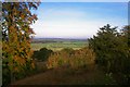
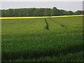
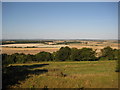
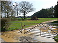
Nearby Images from Geograph Britain and Ireland:
©2007(licence)
©2008(licence)
©2009(licence)
©2010(licence)
©2006(licence)
The above images may not be of the site on this page, they are loaded from Geograph.
Please Submit an Image of this site or go out and take one for us!
Click here to see more info for this site
Nearby sites
Key: Red: member's photo, Blue: 3rd party photo, Yellow: other image, Green: no photo - please go there and take one, Grey: site destroyed
Download sites to:
KML (Google Earth)
GPX (GPS waypoints)
CSV (Garmin/Navman)
CSV (Excel)
To unlock full downloads you need to sign up as a Contributory Member. Otherwise downloads are limited to 50 sites.
Turn off the page maps and other distractions
Nearby sites listing. In the following links * = Image available
100m E 90° Danebury East Long Barrow (SU320383)
757m SE 144° Danebury Ring* Hillfort (SU32353769)
5.1km WSW 238° Lopcombe Disc Barrow Round Barrow(s) (SU27563561)
5.7km WNW 294° Palestine Bowl Barrow* Round Barrow(s) (SU26684060)
5.8km NNE 27° Bury Hill (Hampshire)* Hillfort (SU345435)
6.7km W 275° Martin's Clump Flint Mine Ancient Mine, Quarry or other Industry (SU252388)
6.8km W 276° Martin's Clump Bowl Barrow Round Barrow(s) (SU25133896)
6.8km ESE 122° Stockbridge Down Bowl Barrows* Round Barrow(s) (SU377347)
6.8km W 272° Martin's Clump Long Barrow Long Barrow (SU25053845)
6.9km ESE 116° Woolbury* Hillfort (SU381353)
7.0km NW 305° Quarley Hill* Hillfort (SU262423)
7.2km ESE 119° Stockbridge Down field boundary* Misc. Earthwork (SU382348)
7.7km ENE 71° St Peter and Holy Cross (Wherwell) Ancient Cross (SU39154082)
7.9km WNW 288° Grateley Down Barrows* Barrow Cemetery (SU24414074)
8.4km WNW 299° Barrow Field Clumps* Barrow Cemetery (SU2446242274)
8.8km NNE 32° Andover Museum of the Iron Age* Museum (SU36614579)
9.0km N 9° Penton Park Bowl Barrow Round Barrow(s) (SU3326247217)
9.8km E 90° Middlebarn Farm Long Barrow Long Barrow (SU4177438299)
10.0km NE 51° Old Pound Camp Misc. Earthwork (SU39634465)
11.3km N 6° Nutbane* Long Barrow (SU33104952)
11.8km WSW 253° Battery Hill Bowl Barrow Round Barrow(s) (SU20573485)
11.9km WSW 253° Battery Hill Long Barrow Long Barrow (SU20493481)
11.9km SE 141° Withering Corner Barrow Cemetery (SU395291)
11.9km SSE 158° Stubb's Copse Round Barrow(s) (SU36362722)
12.4km WSW 249° Thorny Down Enclosure Ancient Village or Settlement (SU203338)
View more nearby sites and additional images


 We would like to know more about this location. Please feel free to add a brief description and any relevant information in your own language.
 Wir möchten mehr über diese Stätte erfahren. Bitte zögern Sie nicht, eine kurze Beschreibung und relevante Informationen in Deutsch hinzuzufügen.
 Nous aimerions en savoir encore un peu sur les lieux. S'il vous plaît n'hesitez pas à ajouter une courte description et tous les renseignements pertinents dans votre propre langue.
 Quisieramos informarnos un poco más de las lugares. No dude en añadir una breve descripción y otros datos relevantes en su propio idioma.