


<< Our Photo Pages >> St Marys (Astbury) - Ancient Cross in England in Cheshire
Submitted by TimPrevett on Sunday, 23 April 2006 Page Views: 10074
Early Medieval (Dark Age)Site Name: St Marys (Astbury)Country: England County: Cheshire Type: Ancient Cross
Nearest Town: Congleton Nearest Village: Astbury
Map Ref: SJ847615
Latitude: 53.150415N Longitude: 2.230227W
Condition:
| 5 | Perfect |
| 4 | Almost Perfect |
| 3 | Reasonable but with some damage |
| 2 | Ruined but still recognisable as an ancient site |
| 1 | Pretty much destroyed, possibly visible as crop marks |
| 0 | No data. |
| -1 | Completely destroyed |
| 5 | Superb |
| 4 | Good |
| 3 | Ordinary |
| 2 | Not Good |
| 1 | Awful |
| 0 | No data. |
| 5 | Can be driven to, probably with disabled access |
| 4 | Short walk on a footpath |
| 3 | Requiring a bit more of a walk |
| 2 | A long walk |
| 1 | In the middle of nowhere, a nightmare to find |
| 0 | No data. |
| 5 | co-ordinates taken by GPS or official recorded co-ordinates |
| 4 | co-ordinates scaled from a detailed map |
| 3 | co-ordinates scaled from a bad map |
| 2 | co-ordinates of the nearest village |
| 1 | co-ordinates of the nearest town |
| 0 | no data |
Internal Links:
External Links:
I have visited· I would like to visit
elad13 visited on 21st Dec 2023 - their rating: Cond: 4 Amb: 4 Access: 4
 (PID:20287)")
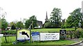
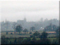
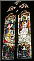
Part of a Saxon cross shaft to the rear of the Church, above a doorway in the North West corner. Spirals and curved motifs are visble on the outward facing side. An Anglo Saxon church once stood on the site. Also of interest is a 2,000 year old hollow yew tree to the North East of the original churchyard. If visiting in April, the triangular green to the west of the church is covered in daffodils, making a most breathtaking spectacle. Access to the church subject to church opening. Church website HERE.
You may be viewing yesterday's version of this page. To see the most up to date information please register for a free account.
 (PID:20290)")
 (PID:20289)")
 (PID:20286)")
Do not use the above information on other web sites or publications without permission of the contributor.
Nearby Images from Geograph Britain and Ireland:
©2019(licence)
©2011(licence)
©2022(licence)
©2022(licence)
©2022(licence)
The above images may not be of the site on this page, they are loaded from Geograph.
Please Submit an Image of this site or go out and take one for us!
Click here to see more info for this site
Nearby sites
Key: Red: member's photo, Blue: 3rd party photo, Yellow: other image, Green: no photo - please go there and take one, Grey: site destroyed
Download sites to:
KML (Google Earth)
GPX (GPS waypoints)
CSV (Garmin/Navman)
CSV (Excel)
To unlock full downloads you need to sign up as a Contributory Member. Otherwise downloads are limited to 50 sites.
Turn off the page maps and other distractions
Nearby sites listing. In the following links * = Image available
223m WNW 296° Astbury Churchyard* Round Barrow(s) (SJ845616)
1.8km NE 40° Congleton Museum* Museum (SJ859629)
2.5km NW 318° Loachbrook Farm* Long Barrow (SJ830634)
3.0km SSW 210° Little Moreton Hall* Round Barrow(s) (SJ832589)
4.7km NW 310° Somerford Round Barrow Round Barrow(s) (SJ811645)
5.0km ESE 102° Shepherd's Cross* Standing Stone (Menhir) (SJ89626042)
5.8km SE 144° Red Cross* Ancient Cross (SJ881568)
5.9km E 83° The Bridestones (Cheshire)* Chambered Tomb (SJ9058962190)
6.2km ENE 70° Bosley Cloud (1)* Standing Stone (Menhir) (SJ905636)
6.2km ENE 72° Bosley Cloud (2)* Standing Stone (Menhir) (SJ906634)
6.2km NNW 327° Swettenham Hall* Round Barrow(s) (SJ813667)
6.3km SSW 204° All Saints (Church Lawton)* Artificial Mound (SJ82165573)
6.8km SW 214° Church Lawton Barrows* Barrow Cemetery (SJ809559)
7.0km SSW 214° Church Lawton South* Stone Circle (SJ808557)
7.3km NW 321° St Peter (Swettenham) Ancient Cross (SJ80086718)
7.8km SE 139° Gawton's Well* Holy Well or Sacred Spring (SJ89825555)
7.9km SE 140° Gawton's Stone* Modern Stone Circle etc (SJ898554)
8.7km E 86° Satan's Stone* Natural Stone / Erratic / Other Natural Feature (SJ93406206)
8.8km W 265° Sandbach Crosses* Ancient Cross (SJ7587760825)
9.4km E 85° St Helen's Well (Rushton Spencer)* Holy Well or Sacred Spring (SJ94076222)
10.0km S 169° Tunstall Park* Natural Stone / Erratic / Other Natural Feature (SJ865517)
10.1km NNE 14° Lower Pexhill Round Barrow(s) (SJ872713)
10.1km ENE 64° Bosley Minn 1* Standing Stone (Menhir) (SJ93886585)
10.3km ENE 64° Bosley Minn 2 & 3* Standing Stones (SJ940660)
10.4km ENE 63° Bosley Minn 4 & 5* Standing Stones (SJ940662)
View more nearby sites and additional images


 We would like to know more about this location. Please feel free to add a brief description and any relevant information in your own language.
 Wir möchten mehr über diese Stätte erfahren. Bitte zögern Sie nicht, eine kurze Beschreibung und relevante Informationen in Deutsch hinzuzufügen.
 Nous aimerions en savoir encore un peu sur les lieux. S'il vous plaît n'hesitez pas à ajouter une courte description et tous les renseignements pertinents dans votre propre langue.
 Quisieramos informarnos un poco más de las lugares. No dude en añadir una breve descripción y otros datos relevantes en su propio idioma.