


<< Our Photo Pages >> Ffynnon Gybi - Holy Well or Sacred Spring in Wales in Anglesey
Submitted by TimPrevett on Monday, 12 February 2007 Page Views: 7870
Springs and Holy WellsSite Name: Ffynnon GybiCountry: Wales County: Anglesey Type: Holy Well or Sacred Spring
Nearest Town: Benllech Nearest Village: Maenaddwyn
Map Ref: SH44908414
Latitude: 53.331376N Longitude: 4.330566W
Condition:
| 5 | Perfect |
| 4 | Almost Perfect |
| 3 | Reasonable but with some damage |
| 2 | Ruined but still recognisable as an ancient site |
| 1 | Pretty much destroyed, possibly visible as crop marks |
| 0 | No data. |
| -1 | Completely destroyed |
| 5 | Superb |
| 4 | Good |
| 3 | Ordinary |
| 2 | Not Good |
| 1 | Awful |
| 0 | No data. |
| 5 | Can be driven to, probably with disabled access |
| 4 | Short walk on a footpath |
| 3 | Requiring a bit more of a walk |
| 2 | A long walk |
| 1 | In the middle of nowhere, a nightmare to find |
| 0 | No data. |
| 5 | co-ordinates taken by GPS or official recorded co-ordinates |
| 4 | co-ordinates scaled from a detailed map |
| 3 | co-ordinates scaled from a bad map |
| 2 | co-ordinates of the nearest village |
| 1 | co-ordinates of the nearest town |
| 0 | no data |
Internal Links:
External Links:
")
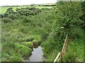
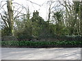
Ffynnon Gybi, a healing well adjacent the road on the southern side of the bridge between Llanerchymedd and Maenaddwyn. Ffynnon Deiniol was on the opposite side of the road but can no longer be traced.
You may be viewing yesterday's version of this page. To see the most up to date information please register for a free account.
")
Do not use the above information on other web sites or publications without permission of the contributor.
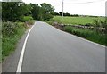
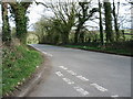
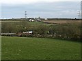
Nearby Images from Geograph Britain and Ireland:
©2009(licence)
©2009(licence)
©2009(licence)
©2009(licence)
©2009(licence)
The above images may not be of the site on this page, they are loaded from Geograph.
Please Submit an Image of this site or go out and take one for us!
Click here to see more info for this site
Nearby sites
Key: Red: member's photo, Blue: 3rd party photo, Yellow: other image, Green: no photo - please go there and take one, Grey: site destroyed
Download sites to:
KML (Google Earth)
GPX (GPS waypoints)
CSV (Garmin/Navman)
CSV (Excel)
To unlock full downloads you need to sign up as a Contributory Member. Otherwise downloads are limited to 50 sites.
Turn off the page maps and other distractions
Nearby sites listing. In the following links * = Image available
20m N 358° Ffynnon Deiniol* Holy Well or Sacred Spring (SH44908416)
45m NW 324° Clorach Wells* Not Known (by us) (SH4487584177)
339m WNW 296° Carreg Leidr* Standing Stone (Menhir) (SH446843)
1.1km ESE 113° Llanfihangel Tre'r Beirdd Cross* Ancient Cross (SH4588783693)
1.1km SSE 162° Llech Golman* Standing Stone (Menhir) (SH452831)
1.3km W 279° Llwydiarth Esgob Stone* Rock Art (SH436844)
1.4km ESE 120° Maen Addwyn* Standing Stone (Menhir) (SH461834)
2.2km W 276° Bedd y Foel* Burial Chamber or Dolmen (SH42698444)
2.3km NW 312° Maen Chwyf* Natural Stone / Erratic / Other Natural Feature (SH43268574)
2.5km NW 313° Bryn Dyfrydog* Standing Stone (Menhir) (SH431859)
3.1km ENE 62° Ponc y Garreg Hir* Standing Stone (Menhir) (SH47668549)
3.9km E 95° Frigan Field System Misc. Earthwork (SH488837)
3.9km ENE 74° Tyddyn Isaf Burnt Mound Misc. Earthwork (SH4873185067)
4.2km WSW 246° Mynydd Mwyn Mawr standing stones* Standing Stones (SH41058256)
4.2km ENE 75° Bwlch-Y-Dafarn Enclosed Settlement Ancient Village or Settlement (SH4900085103)
4.3km ENE 66° Rhos Lligwy Burnt Mound Misc. Earthwork (SH4888185780)
4.3km ENE 73° Bwlch-Y-Dafarn Settlement Enclosure Ancient Village or Settlement (SH4910585235)
4.5km ENE 65° Coed Newydd Burnt Mounds Misc. Earthwork (SH4904885932)
4.6km E 81° Parciau Hillfort Hillfort (SH4945384676)
4.6km ENE 69° Bwlch-Y-Dafarn Ancient Village or Settlement (SH4929285663)
5.0km E 81° Ffynnon Allgo Holy Well or Sacred Spring (SH4989684774)
5.2km ENE 66° Din Lligwy* Ancient Village or Settlement (SH4970286134)
5.2km WSW 256° Carmel Standing Stone* Standing Stone (Menhir) (SH39798304)
5.3km E 82° Cae Marh Ancient Village or Settlement (SH5016784694)
5.3km ENE 74° Llanallgo Roundhouse Ancient Village or Settlement (SH5008185471)
View more nearby sites and additional images


 We would like to know more about this location. Please feel free to add a brief description and any relevant information in your own language.
 Wir möchten mehr über diese Stätte erfahren. Bitte zögern Sie nicht, eine kurze Beschreibung und relevante Informationen in Deutsch hinzuzufügen.
 Nous aimerions en savoir encore un peu sur les lieux. S'il vous plaît n'hesitez pas à ajouter une courte description et tous les renseignements pertinents dans votre propre langue.
 Quisieramos informarnos un poco más de las lugares. No dude en añadir una breve descripción y otros datos relevantes en su propio idioma.