


<< Our Photo Pages >> High Plantation (Bransdale Moor) - Round Cairn in England in Yorkshire (North)
Submitted by johndhunter on Wednesday, 25 July 2018 Page Views: 994
Neolithic and Bronze AgeSite Name: High Plantation (Bransdale Moor)Country: England County: Yorkshire (North) Type: Round Cairn
Nearest Village: Chop Gate
Map Ref: SE6165499324
Latitude: 54.385682N Longitude: 1.052152W
Condition:
| 5 | Perfect |
| 4 | Almost Perfect |
| 3 | Reasonable but with some damage |
| 2 | Ruined but still recognisable as an ancient site |
| 1 | Pretty much destroyed, possibly visible as crop marks |
| 0 | No data. |
| -1 | Completely destroyed |
| 5 | Superb |
| 4 | Good |
| 3 | Ordinary |
| 2 | Not Good |
| 1 | Awful |
| 0 | No data. |
| 5 | Can be driven to, probably with disabled access |
| 4 | Short walk on a footpath |
| 3 | Requiring a bit more of a walk |
| 2 | A long walk |
| 1 | In the middle of nowhere, a nightmare to find |
| 0 | No data. |
| 5 | co-ordinates taken by GPS or official recorded co-ordinates |
| 4 | co-ordinates scaled from a detailed map |
| 3 | co-ordinates scaled from a bad map |
| 2 | co-ordinates of the nearest village |
| 1 | co-ordinates of the nearest town |
| 0 | no data |
Internal Links:
External Links:
 (PID:184073)")
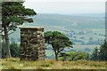
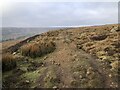
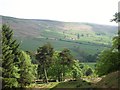
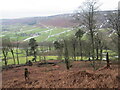
This round cairn is located in High Plantation north east of Cockayne Lodge. It is in a prominent position with an excellent view down the length of Bransdale . There is inter visibility of this cairn with other cairns to the west on Bransdale Ridge and the round barrows and Cammon Stone (Standing Stone) to the east on Rudland Rigg. It is Historic England List Entry Number 1019597 and full details and description can be found there. This cairn is a bit out of the way and which ever way you approach it there is a fair bit of walking involved however, if you go on a nice sunny day you will be rewarded with some fine views looking down Bransdale, which in itself is off the beaten track as there is no through road, only two very minor access roads from the south.
You may be viewing yesterday's version of this page. To see the most up to date information please register for a free account.
 (PID:184075)")
 (PID:184074)")
 (PID:184072)")
 (PID:184071)")
Do not use the above information on other web sites or publications without permission of the contributor.
Nearby Images from Geograph Britain and Ireland:
©2019(licence)
©2022(licence)
©2016(licence)
©2011(licence)
©2020(licence)
The above images may not be of the site on this page, they are loaded from Geograph.
Please Submit an Image of this site or go out and take one for us!
Click here to see more info for this site
Nearby sites
Key: Red: member's photo, Blue: 3rd party photo, Yellow: other image, Green: no photo - please go there and take one, Grey: site destroyed
Download sites to:
KML (Google Earth)
GPX (GPS waypoints)
CSV (Garmin/Navman)
CSV (Excel)
To unlock full downloads you need to sign up as a Contributory Member. Otherwise downloads are limited to 50 sites.
Turn off the page maps and other distractions
Nearby sites listing. In the following links * = Image available
1.2km ENE 57° Cammon Stone* Standing Stone (Menhir) (SE6263199980)
1.3km WNW 292° Bransdale Moor Stone Circle Stone Circle (SE604998)
1.5km E 101° Cockan Cross* Ancient Cross (SE6311599071)
1.5km SW 221° Stump Cross (Bransdale Ridge)* Ancient Cross (SE6068698172)
1.6km NW 313° Badger Stone (Todd Intake Moor)* Natural Stone / Erratic / Other Natural Feature (NZ6044500423)
1.7km W 279° Crook Staff Hill* Round Barrow(s) (SE5993599584)
1.8km WSW 248° Slape Wath Moor Waymarkers* Marker Stone (SE6002998645)
1.8km SE 125° Three Howes Northern (Bransdale)* Round Barrow(s) (SE6313398338)
1.8km SE 126° Three Howes Central (Bransdale)* Round Barrow(s) (SE6314298276)
1.9km SSW 212° Round Barrow 400m south of Stump Cross* Round Barrow(s) (SE6067997744)
1.9km SE 127° Three Howes Southern Pair (Bransdale)* Cairn (SE6321598186)
2.1km N 360° Rudland Rigg Guide Stone GS2* Marker Stone (NZ6161301430)
2.1km SSW 207° Round Barrow 900m west of Colt House Farm* Round Barrow(s) (SE6069997426)
2.5km SSW 204° Bransdale Ridge (Low Cornfield House)* Round Barrow(s) (SE6068997032)
2.5km ESE 122° Rudland Rigg Guide Stone GS1* Marker Stone (SE6378898039)
2.7km SSW 201° Bransdale Ridge (Cowl House)* Round Barrow(s) (SE6073496810)
2.9km NW 318° Face Stone (Urra Moor)* Standing Stone (Menhir) (NZ5968701442)
2.9km WNW 293° High Cable Stone (Tripsdale)* Natural Stone / Erratic / Other Natural Feature (NZ5896400446)
2.9km WNW 290° Upper Tripsdale Earthwork* Misc. Earthwork (NZ5887500296)
3.0km WNW 287° Low Cable Stone (Tripsdale)* Natural Stone / Erratic / Other Natural Feature (NZ5878400147)
3.0km N 351° Jenny Bradley Cross* Ancient Cross (NZ6112502309)
3.1km NW 315° Hand Stone (Urra Moor)* Standing Stone (Menhir) (NZ5942701513)
3.2km WNW 291° Collar Ridge Marker Stone* Marker Stone (NZ5868400435)
3.2km NW 316° Round Hill East* Round Barrow(s) (NZ59430159)
3.2km SSW 194° Bransdale Ridge BS2* Marker Stone (SE6092596195)
View more nearby sites and additional images


 We would like to know more about this location. Please feel free to add a brief description and any relevant information in your own language.
 Wir möchten mehr über diese Stätte erfahren. Bitte zögern Sie nicht, eine kurze Beschreibung und relevante Informationen in Deutsch hinzuzufügen.
 Nous aimerions en savoir encore un peu sur les lieux. S'il vous plaît n'hesitez pas à ajouter une courte description et tous les renseignements pertinents dans votre propre langue.
 Quisieramos informarnos un poco más de las lugares. No dude en añadir una breve descripción y otros datos relevantes en su propio idioma.