


<< Our Photo Pages >> Bransdale Ridge BS2 - Marker Stone in England in Yorkshire (North)
Submitted by johndhunter on Wednesday, 10 January 2024 Page Views: 128
Modern SitesSite Name: Bransdale Ridge BS2Country: England County: Yorkshire (North) Type: Marker Stone
Nearest Town: Kirkbymoorside Nearest Village: Cockayne
Map Ref: SE6092596195
Latitude: 54.357652N Longitude: 1.064015W
Condition:
| 5 | Perfect |
| 4 | Almost Perfect |
| 3 | Reasonable but with some damage |
| 2 | Ruined but still recognisable as an ancient site |
| 1 | Pretty much destroyed, possibly visible as crop marks |
| 0 | No data. |
| -1 | Completely destroyed |
| 5 | Superb |
| 4 | Good |
| 3 | Ordinary |
| 2 | Not Good |
| 1 | Awful |
| 0 | No data. |
| 5 | Can be driven to, probably with disabled access |
| 4 | Short walk on a footpath |
| 3 | Requiring a bit more of a walk |
| 2 | A long walk |
| 1 | In the middle of nowhere, a nightmare to find |
| 0 | No data. |
| 5 | co-ordinates taken by GPS or official recorded co-ordinates |
| 4 | co-ordinates scaled from a detailed map |
| 3 | co-ordinates scaled from a bad map |
| 2 | co-ordinates of the nearest village |
| 1 | co-ordinates of the nearest town |
| 0 | no data |
Internal Links:
External Links:
")
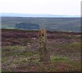
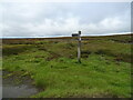
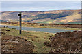
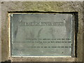
A squared, slightly tapered C18 monolith about 5ft in height and made of sandstone. It is one of about ten such stones in a boundary line string that runs along Bransdale Ridge. It has the letter K (Kirkdale) engraved on its east face and H (Helmsley) on its west face.
This particular stone which is also grade II listed Entry Number 1149036 stands by a trail that originates in the Fangdale Beck area of Bilsdale and comes across Bilsdale East Moor. It no doubt will have been an important route between the dales in times past.
For details of boundaries regarding this stone see nearby site BRANSDALE RIDGE BS1
You may be viewing yesterday's version of this page. To see the most up to date information please register for a free account.
")
Do not use the above information on other web sites or publications without permission of the contributor.
Nearby Images from Geograph Britain and Ireland:
©2012(licence)
©2020(licence)
©2011(licence)
©2015(licence)
©2011(licence)
The above images may not be of the site on this page, they are loaded from Geograph.
Please Submit an Image of this site or go out and take one for us!
Click here to see more info for this site
Nearby sites
Key: Red: member's photo, Blue: 3rd party photo, Yellow: other image, Green: no photo - please go there and take one, Grey: site destroyed
Download sites to:
KML (Google Earth)
GPX (GPS waypoints)
CSV (Garmin/Navman)
CSV (Excel)
To unlock full downloads you need to sign up as a Contributory Member. Otherwise downloads are limited to 50 sites.
Turn off the page maps and other distractions
Nearby sites listing. In the following links * = Image available
643m NNW 344° Bransdale Ridge (Cowl House)* Round Barrow(s) (SE6073496810)
706m SSE 166° Locking Stone (Bransdale)* Marker Stone (SE6110495511)
809m SSE 161° Bransdale West Guide Stone GS1* Marker Stone (SE6120495435)
869m NNW 345° Bransdale Ridge (Low Cornfield House)* Round Barrow(s) (SE6068997032)
1.3km N 350° Round Barrow 900m west of Colt House Farm* Round Barrow(s) (SE6069997426)
1.6km N 352° Round Barrow 400m south of Stump Cross* Round Barrow(s) (SE6067997744)
1.6km W 266° Loosehow Hill MS1* Marker Stone (SE5934496060)
1.9km SW 236° Money Howe* Round Barrow(s) (SE59379511)
2.0km N 354° Stump Cross (Bransdale Ridge)* Ancient Cross (SE6068698172)
2.6km NNW 341° Slape Wath Moor Waymarkers* Marker Stone (SE6002998645)
3.0km NE 50° Three Howes Southern Pair (Bransdale)* Cairn (SE6321598186)
3.0km NE 48° Three Howes Central (Bransdale)* Round Barrow(s) (SE6314298276)
3.1km NE 47° Three Howes Northern (Bransdale)* Round Barrow(s) (SE6313398338)
3.1km SW 231° Coniser Howl RB1* Round Barrow(s) (SE5849894180)
3.2km NNE 14° High Plantation (Bransdale Moor)* Round Cairn (SE6165499324)
3.4km ENE 58° Rudland Rigg Guide Stone GS1* Marker Stone (SE6378898039)
3.5km NNW 345° Crook Staff Hill* Round Barrow(s) (SE5993599584)
3.6km NE 38° Cockan Cross* Ancient Cross (SE6311599071)
3.6km NW 313° Ship Stone (Tripsdale)* Natural Stone / Erratic / Other Natural Feature (SE5822698640)
3.6km N 352° Bransdale Moor Stone Circle Stone Circle (SE604998)
3.8km WNW 298° Nab Ridge* Round Barrow(s) (SE5756497909)
3.8km WNW 298° Cam House (Chop Gate)* Round Barrow(s) (SE5757097948)
3.8km E 89° Golden Heights Ring Cairn and Wayside Cross* Ring Cairn (SE6472496300)
3.9km SW 215° Roppa Cross North* Ancient Cross (SE5869992992)
4.1km SW 218° Carr Cote Ridge (Laskill Pasture Moor)* Round Barrow(s) (SE5844092920)
View more nearby sites and additional images


 We would like to know more about this location. Please feel free to add a brief description and any relevant information in your own language.
 Wir möchten mehr über diese Stätte erfahren. Bitte zögern Sie nicht, eine kurze Beschreibung und relevante Informationen in Deutsch hinzuzufügen.
 Nous aimerions en savoir encore un peu sur les lieux. S'il vous plaît n'hesitez pas à ajouter une courte description et tous les renseignements pertinents dans votre propre langue.
 Quisieramos informarnos un poco más de las lugares. No dude en añadir una breve descripción y otros datos relevantes en su propio idioma.