


<< Our Photo Pages >> Slape Wath Moor Waymarkers - Marker Stone in England in Yorkshire (North)
Submitted by johndhunter on Friday, 26 May 2023 Page Views: 429
Modern SitesSite Name: Slape Wath Moor WaymarkersCountry: England County: Yorkshire (North) Type: Marker Stone
Nearest Town: Stokesley Nearest Village: Chop Gate
Map Ref: SE6002998645
Latitude: 54.379774N Longitude: 1.077307W
Condition:
| 5 | Perfect |
| 4 | Almost Perfect |
| 3 | Reasonable but with some damage |
| 2 | Ruined but still recognisable as an ancient site |
| 1 | Pretty much destroyed, possibly visible as crop marks |
| 0 | No data. |
| -1 | Completely destroyed |
| 5 | Superb |
| 4 | Good |
| 3 | Ordinary |
| 2 | Not Good |
| 1 | Awful |
| 0 | No data. |
| 5 | Can be driven to, probably with disabled access |
| 4 | Short walk on a footpath |
| 3 | Requiring a bit more of a walk |
| 2 | A long walk |
| 1 | In the middle of nowhere, a nightmare to find |
| 0 | No data. |
| 5 | co-ordinates taken by GPS or official recorded co-ordinates |
| 4 | co-ordinates scaled from a detailed map |
| 3 | co-ordinates scaled from a bad map |
| 2 | co-ordinates of the nearest village |
| 1 | co-ordinates of the nearest town |
| 0 | no data |
Internal Links:
External Links:
")
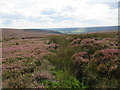
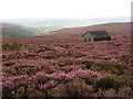
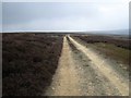
Two Waymarkers one (WM1) at SE 60029 98645 and the other (WM2) at SE 59427 98719 about 0.4 miles to the west. They lie just off to one side of the modern day shooters track that crosses Slape Wath Moor. Originally they will have marked the route which branched off from the Thurkilsti* at STUMP CROSS on Bransdale Ridge. This route which will have followed an ancient trackway went from Stump Cross crossing Slape Wath Moor, then across Tripsdale up onto Nab End Moor then down into Bilsdale and on to Chop Gate via William Beck Farm.
The stones are the NYMNPA HER numbers 22977 (WM1) and 22978 (WM2) respectively which describes them as post medieval waymarkers. I note that historical OS maps show half a dozen or so stones beside the route across Slape Wath Moor even up to 1952 they are still marked, however it would appear that these are now the only two left. See HERE for a view of the 1952 map. When the map opens go to midway extreme right to locate Slape Wath Moor. As to why you would need so many wayfarer stones across this short section of moor and not along the rest of the route, my guess is that the moor may have been very boggy in times past. The word Wath is derived from an Old Norse word meaning Ford.
Note: The prefixes WM1 and WM2 are my designations for the stones.
*Thurkilsti – One of the main north south routes across the moors which will have had its origins in prehistoric times. For a full description of its route see the information provided in the site description for the BRANSDALE WEST GUIDE STONE
You may be viewing yesterday's version of this page. To see the most up to date information please register for a free account.
")
")
Do not use the above information on other web sites or publications without permission of the contributor.
Nearby Images from Geograph Britain and Ireland:
©2017(licence)
©2022(licence)
©2005(licence)
©2011(licence)
©2010(licence)
The above images may not be of the site on this page, they are loaded from Geograph.
Please Submit an Image of this site or go out and take one for us!
Click here to see more info for this site
Nearby sites
Key: Red: member's photo, Blue: 3rd party photo, Yellow: other image, Green: no photo - please go there and take one, Grey: site destroyed
Download sites to:
KML (Google Earth)
GPX (GPS waypoints)
CSV (Garmin/Navman)
CSV (Excel)
To unlock full downloads you need to sign up as a Contributory Member. Otherwise downloads are limited to 50 sites.
Turn off the page maps and other distractions
Nearby sites listing. In the following links * = Image available
808m SE 127° Stump Cross (Bransdale Ridge)* Ancient Cross (SE6068698172)
943m N 355° Crook Staff Hill* Round Barrow(s) (SE5993599584)
1.1km SE 145° Round Barrow 400m south of Stump Cross* Round Barrow(s) (SE6067997744)
1.2km NNE 19° Bransdale Moor Stone Circle Stone Circle (SE604998)
1.4km SSE 152° Round Barrow 900m west of Colt House Farm* Round Barrow(s) (SE6069997426)
1.7km SSE 159° Bransdale Ridge (Low Cornfield House)* Round Barrow(s) (SE6068997032)
1.8km ENE 68° High Plantation (Bransdale Moor)* Round Cairn (SE6165499324)
1.8km W 271° Ship Stone (Tripsdale)* Natural Stone / Erratic / Other Natural Feature (SE5822698640)
1.8km NNE 14° Badger Stone (Todd Intake Moor)* Natural Stone / Erratic / Other Natural Feature (NZ6044500423)
1.9km NW 321° Low Cable Stone (Tripsdale)* Natural Stone / Erratic / Other Natural Feature (NZ5878400147)
2.0km SSE 160° Bransdale Ridge (Cowl House)* Round Barrow(s) (SE6073496810)
2.0km NW 326° Upper Tripsdale Earthwork* Misc. Earthwork (NZ5887500296)
2.1km NNW 330° High Cable Stone (Tripsdale)* Natural Stone / Erratic / Other Natural Feature (NZ5896400446)
2.2km NW 324° Collar Ridge Marker Stone* Marker Stone (NZ5868400435)
2.4km WNW 282° Black Intake Stone (Nab End Moor)* Marker Stone (SE5766099122)
2.5km NNW 327° Collar Ridge Pillar Cairn* Cairn (NZ5866800700)
2.5km WSW 255° Cam House (Chop Gate)* Round Barrow(s) (SE5757097948)
2.6km WSW 254° Nab Ridge* Round Barrow(s) (SE5756497909)
2.6km SSE 161° Bransdale Ridge BS2* Marker Stone (SE6092596195)
2.7km SSW 196° Loosehow Hill MS1* Marker Stone (SE5934496060)
2.7km NNW 335° North Gill Head (Urra Moor)* Rock Art (NZ5884101119)
2.8km N 354° Face Stone (Urra Moor)* Standing Stone (Menhir) (NZ5968701442)
2.9km ENE 64° Cammon Stone* Standing Stone (Menhir) (SE6263199980)
2.9km N 349° Hand Stone (Urra Moor)* Standing Stone (Menhir) (NZ5942701513)
3.0km N 349° Round Hill East* Round Barrow(s) (NZ59430159)
View more nearby sites and additional images


 We would like to know more about this location. Please feel free to add a brief description and any relevant information in your own language.
 Wir möchten mehr über diese Stätte erfahren. Bitte zögern Sie nicht, eine kurze Beschreibung und relevante Informationen in Deutsch hinzuzufügen.
 Nous aimerions en savoir encore un peu sur les lieux. S'il vous plaît n'hesitez pas à ajouter une courte description et tous les renseignements pertinents dans votre propre langue.
 Quisieramos informarnos un poco más de las lugares. No dude en añadir una breve descripción y otros datos relevantes en su propio idioma.