
, Aubrey Burl")
<< Our Photo Pages >> Loosehow Hill MS1 - Marker Stone in England in Yorkshire (North)
Submitted by johndhunter on Wednesday, 07 February 2024 Page Views: 103
Modern SitesSite Name: Loosehow Hill MS1Country: England County: Yorkshire (North) Type: Marker Stone
Nearest Town: Helmsley Nearest Village: Chop Gate
Map Ref: SE5934496060
Latitude: 54.356625N Longitude: 1.088366W
Condition:
| 5 | Perfect |
| 4 | Almost Perfect |
| 3 | Reasonable but with some damage |
| 2 | Ruined but still recognisable as an ancient site |
| 1 | Pretty much destroyed, possibly visible as crop marks |
| 0 | No data. |
| -1 | Completely destroyed |
| 5 | Superb |
| 4 | Good |
| 3 | Ordinary |
| 2 | Not Good |
| 1 | Awful |
| 0 | No data. |
| 5 | Can be driven to, probably with disabled access |
| 4 | Short walk on a footpath |
| 3 | Requiring a bit more of a walk |
| 2 | A long walk |
| 1 | In the middle of nowhere, a nightmare to find |
| 0 | No data. |
| 5 | co-ordinates taken by GPS or official recorded co-ordinates |
| 4 | co-ordinates scaled from a detailed map |
| 3 | co-ordinates scaled from a bad map |
| 2 | co-ordinates of the nearest village |
| 1 | co-ordinates of the nearest town |
| 0 | no data |
Internal Links:
External Links:
")
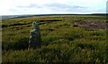
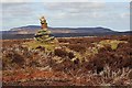
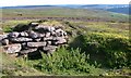
A bit of a puzzle this one, it does not appear to be a boundary stone and does not appear on any historical mapping and yet it appears to be well worn as if it had been there for some time
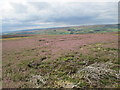
It stands at or very close to the summit of Loosehow Hill on Bilsdale East Moor, just to the east of a very modern shooters track. Earlier historical maps (pre 1900) also show tracks in this area going to Lime Kilns and Quarries. However later historical maps (post 1900) show none of this, just the bare moor. So is it an older wayfarer stone marking the route to the kilns or just a very modern stone stuck up by someone to mark the summit when they built the shooters track?
As for the stone itself, though I didn’t measure it, its probably about 3ft high maybe a bit more and as there are old limestone quarries in the area is probably made of limestone. It is quite conspicuous and stands out clearly from the heather. I was just walking across the open moor west to east and it caught my attention, I wasn’t even expecting the shooters track as the older OS paper map (2002 edition) I was using a the time (2017) did not show it, so it was something of a surprise to spot the stone.
You may be viewing yesterday's version of this page. To see the most up to date information please register for a free account.
")
")
")
")
Do not use the above information on other web sites or publications without permission of the contributor.
Nearby Images from Geograph Britain and Ireland:
©2006(licence)
©2010(licence)
©2014(licence)
©2006(licence)
©2014(licence)
The above images may not be of the site on this page, they are loaded from Geograph.
Please Submit an Image of this site or go out and take one for us!
Click here to see more info for this site
Nearby sites
Key: Red: member's photo, Blue: 3rd party photo, Yellow: other image, Green: no photo - please go there and take one, Grey: site destroyed
Download sites to:
KML (Google Earth)
GPX (GPS waypoints)
CSV (Garmin/Navman)
CSV (Excel)
To unlock full downloads you need to sign up as a Contributory Member. Otherwise downloads are limited to 50 sites.
Turn off the page maps and other distractions
Nearby sites listing. In the following links * = Image available
950m S 179° Money Howe* Round Barrow(s) (SE59379511)
1.6km ENE 62° Bransdale Ridge (Cowl House)* Round Barrow(s) (SE6073496810)
1.6km E 86° Bransdale Ridge BS2* Marker Stone (SE6092596195)
1.7km NE 55° Bransdale Ridge (Low Cornfield House)* Round Barrow(s) (SE6068997032)
1.8km ESE 108° Locking Stone (Bransdale)* Marker Stone (SE6110495511)
1.9km NE 45° Round Barrow 900m west of Colt House Farm* Round Barrow(s) (SE6069997426)
2.0km ESE 109° Bransdale West Guide Stone GS1* Marker Stone (SE6120495435)
2.1km SSW 205° Coniser Howl RB1* Round Barrow(s) (SE5849894180)
2.1km NE 39° Round Barrow 400m south of Stump Cross* Round Barrow(s) (SE6067997744)
2.5km NNE 33° Stump Cross (Bransdale Ridge)* Ancient Cross (SE6068698172)
2.6km NW 317° Nab Ridge* Round Barrow(s) (SE5756497909)
2.6km NW 318° Cam House (Chop Gate)* Round Barrow(s) (SE5757097948)
2.7km NNE 16° Slape Wath Moor Waymarkers* Marker Stone (SE6002998645)
2.8km NNW 337° Ship Stone (Tripsdale)* Natural Stone / Erratic / Other Natural Feature (SE5822698640)
3.1km SSW 193° Roppa Cross North* Ancient Cross (SE5869992992)
3.3km SSW 197° Carr Cote Ridge (Laskill Pasture Moor)* Round Barrow(s) (SE5844092920)
3.4km WSW 258° Limestone Ridge (Bilsdale West Moor)* Round Cairn (SE5599595301)
3.5km NNW 332° Black Intake Stone (Nab End Moor)* Marker Stone (SE5766099122)
3.5km S 191° Roppa Cross South* Ancient Cross (SE5872492614)
3.6km N 10° Crook Staff Hill* Round Barrow(s) (SE5993599584)
3.9km S 185° Helmsley Moor RB1* Round Barrow(s) (SE5904992216)
3.9km NNE 16° Bransdale Moor Stone Circle Stone Circle (SE604998)
4.0km NE 36° High Plantation (Bransdale Moor)* Round Cairn (SE6165499324)
4.1km N 353° Low Cable Stone (Tripsdale)* Natural Stone / Erratic / Other Natural Feature (NZ5878400147)
4.1km W 277° Flat Howe (Bilsdale)* Round Barrow(s) (SE55229651)
View more nearby sites and additional images


 We would like to know more about this location. Please feel free to add a brief description and any relevant information in your own language.
 Wir möchten mehr über diese Stätte erfahren. Bitte zögern Sie nicht, eine kurze Beschreibung und relevante Informationen in Deutsch hinzuzufügen.
 Nous aimerions en savoir encore un peu sur les lieux. S'il vous plaît n'hesitez pas à ajouter une courte description et tous les renseignements pertinents dans votre propre langue.
 Quisieramos informarnos un poco más de las lugares. No dude en añadir una breve descripción y otros datos relevantes en su propio idioma.