 with our Megalithic Portal iPhone app")


<< Our Photo Pages >> Roppa Cross South - Ancient Cross in England in Yorkshire (North)
Submitted by johndhunter on Saturday, 14 October 2017 Page Views: 1132
Early Medieval (Dark Age)Site Name: Roppa Cross SouthCountry: England County: Yorkshire (North) Type: Ancient Cross
Map Ref: SE5872492614
Latitude: 54.325731N Longitude: 1.098583W
Condition:
| 5 | Perfect |
| 4 | Almost Perfect |
| 3 | Reasonable but with some damage |
| 2 | Ruined but still recognisable as an ancient site |
| 1 | Pretty much destroyed, possibly visible as crop marks |
| 0 | No data. |
| -1 | Completely destroyed |
| 5 | Superb |
| 4 | Good |
| 3 | Ordinary |
| 2 | Not Good |
| 1 | Awful |
| 0 | No data. |
| 5 | Can be driven to, probably with disabled access |
| 4 | Short walk on a footpath |
| 3 | Requiring a bit more of a walk |
| 2 | A long walk |
| 1 | In the middle of nowhere, a nightmare to find |
| 0 | No data. |
| 5 | co-ordinates taken by GPS or official recorded co-ordinates |
| 4 | co-ordinates scaled from a detailed map |
| 3 | co-ordinates scaled from a bad map |
| 2 | co-ordinates of the nearest village |
| 1 | co-ordinates of the nearest town |
| 0 | no data |
Be the first person to rate this site - see the 'Contribute!' box in the right hand menu.
Internal Links:
External Links:
")
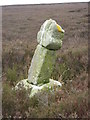
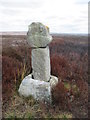
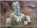
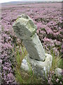
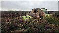
This is Historic Englands List Entry Number 1011746 and full details and description can be found there .
The cross or what remains of it now stands some distance away from the present day track on open moorland. In fact when I first went looking for this about 2011 with only a six figure grid ref. because its quite small and the heather was high, I missed it. An ancient route known as the Via Magna (Great Road) used to run beside the cross which acted as a waymarker. Its original height was 6ft 5 inches , now it is in pieces with part of the original shaft stuck into the medieval base and the ancient wheelhead with the carving of the Maltese cross balanced on top
You may be viewing yesterday's version of this page. To see the most up to date information please register for a free account.
")
")
")
Do not use the above information on other web sites or publications without permission of the contributor.
Nearby Images from Geograph Britain and Ireland:
©2020(licence)
©2020(licence)
©2021(licence)
©2014(licence)
©2021(licence)
The above images may not be of the site on this page, they are loaded from Geograph.
Please Submit an Image of this site or go out and take one for us!
Click here to see more info for this site
Nearby sites
Key: Red: member's photo, Blue: 3rd party photo, Yellow: other image, Green: no photo - please go there and take one, Grey: site destroyed
Download sites to:
KML (Google Earth)
GPX (GPS waypoints)
CSV (Garmin/Navman)
CSV (Excel)
To unlock full downloads you need to sign up as a Contributory Member. Otherwise downloads are limited to 50 sites.
Turn off the page maps and other distractions
Nearby sites listing. In the following links * = Image available
379m N 357° Roppa Cross North* Ancient Cross (SE5869992992)
417m NW 318° Carr Cote Ridge (Laskill Pasture Moor)* Round Barrow(s) (SE5844092920)
513m SE 142° Helmsley Moor RB1* Round Barrow(s) (SE5904992216)
1.6km N 353° Coniser Howl RB1* Round Barrow(s) (SE5849894180)
2.6km NNE 15° Money Howe* Round Barrow(s) (SE59379511)
3.5km N 11° Loosehow Hill MS1* Marker Stone (SE5934496060)
3.7km E 96° Hanging Stone (Pockley Moor)* Standing Stone (Menhir) (SE6241392266)
3.7km NE 40° Locking Stone (Bransdale)* Marker Stone (SE6110495511)
3.7km NE 42° Bransdale West Guide Stone GS1* Marker Stone (SE6120495435)
3.8km NW 315° Limestone Ridge (Bilsdale West Moor)* Round Cairn (SE5599595301)
4.2km NNE 32° Bransdale Ridge BS2* Marker Stone (SE6092596195)
4.6km NNE 26° Bransdale Ridge (Cowl House)* Round Barrow(s) (SE6073496810)
4.7km W 269° Long Hill (Hawnby Moor) MS1* Marker Stone (SE5400192446)
4.7km WNW 283° Round Hill (Hawnby Moor)* Round Barrow(s) (SE5410093616)
4.8km NNE 25° Bransdale Ridge (Low Cornfield House)* Round Barrow(s) (SE6068997032)
4.9km W 267° Long Hill (Hawnby Moor) RB1* Round Barrow(s) (SE5386292307)
4.9km WNW 295° Sour Milk Hills Tumuli* Round Barrow(s) (SE5428194612)
5.2km NNE 23° Round Barrow 900m west of Colt House Farm* Round Barrow(s) (SE6069997426)
5.2km NW 319° Flat Howe (Bilsdale)* Round Barrow(s) (SE55229651)
5.4km W 273° Hazel Head Wood (Hawnby Moor) RB1* Round Barrow(s) (SE5333592868)
5.4km NNW 348° Nab Ridge* Round Barrow(s) (SE5756497909)
5.5km NNW 349° Cam House (Chop Gate)* Round Barrow(s) (SE5757097948)
5.5km NNE 22° Round Barrow 400m south of Stump Cross* Round Barrow(s) (SE6067997744)
5.9km WSW 241° All Saints Church, Hawnby* Ancient Cross (SE53658967)
5.9km NW 314° Joseph Wade's Hut* Round Barrow(s) (SE5445096670)
View more nearby sites and additional images


 We would like to know more about this location. Please feel free to add a brief description and any relevant information in your own language.
 Wir möchten mehr über diese Stätte erfahren. Bitte zögern Sie nicht, eine kurze Beschreibung und relevante Informationen in Deutsch hinzuzufügen.
 Nous aimerions en savoir encore un peu sur les lieux. S'il vous plaît n'hesitez pas à ajouter une courte description et tous les renseignements pertinents dans votre propre langue.
 Quisieramos informarnos un poco más de las lugares. No dude en añadir una breve descripción y otros datos relevantes en su propio idioma.